It's game day again in Wolfpack country! This will be the first game this season we have the full band at where it doesn't rain. Currently I am en route to Winston Salem with the NCSU Power Sound of the South Marching Band in preparation for our third conference game of the season.
We have some history, though bad, in Winston Salem. We have not won away at Wake Forest since 2001, 14 years ago. Philip Rivers, Russel Wilson, and Mike Glennon all tried and failed to pull out a W in Winston Salem.
Gameday Stats
Let's look at some offensive stats from this year. In the 4 games with rain, NC State has put 132 points up on the board. In the two games without rain, NC State has amounted 101 points. In games with rain, NC State put up a total of 1,371 yards of offense and in games without, NC State moved the ball for 1,021 yards. I understand that the comparison for points and yards above does not take into account the difference in difficulty in the conference games against VT and Louisville, however I am just looking at the numbers. NC State is an 8.5 point favorite today with an over/under line of 45 points, and I sure hope it's over that.
Gameday Weather
The weather is going to be gorgeous in Winston Salem today! There is nothing really to speak of. The sun is going to be shining through partly cloudy to mostly sunny skies, and the air closer to the surface will still be relatively dry though moisture may increase slightly with a slight easterly breeze in the afternoon. Those making the drive can expect a temperature of around 60 or 61 at the time of kickoff with a high peaking in the late afternoon after the game reaching about 66-67.
Gameday Items
I only recommend a couple things today: chap stick and sunglasses. The band in the past has been on the east side of the stadium looking west, and the sun has always been directly in our eyes. In addition, the dry air mass we have been experiencing along with the sunshine and a light breeze today can chap lips pretty quickly by evaporating the moisture on your lips. Protect your lips and eyes!
We need your support, Wolfpack Nation! There is plenty of time to still have an awesome season, and it's going to be a larger mental battle than physical battle today! Let's get ourselves a conference win and break a 2-game losing streak in the season and a 6-game losing streak in Winston Salem! Let's go Wolfpack!
Saturday, October 24, 2015
Friday, October 9, 2015
Wolfpack Going Turkey Hunting
It's game day again Wolfpack! Today though we are back out of state, hunting the Hokies in Blacksburg, VA. Unfortunately, it is likely going to be another rain game...
An approaching cold front will help to produce precipitation in Virginia this evening, overnight, and throughout the day tomorrow. The game is at 8:00 tonight and our 100-piece pep band are bringing our ponchos because of the chances for rain tonight. I'm not sure whether Lane Stadium allows umbrellas or not, so it would be a good idea to bring a rain coat with you to have.
Blacksburg
The temperature today is likely going to reach the upper 70's, however tonight ahead of that cold front the temperature is going to drop down into the low 50's. There is a northeasterly breeze which will be persistent but not strong throughout the game helping the temperature to cool off a bit. Tomorrow the cold front will make it's way through Blacksburg and Raleigh, The high tomorrow in Blacksburg will likely not rise out of the 50's, and tomorrow night after the heavier rain and thicker clouds clear out the temperature will drop into the low 40's.
Raleigh
The temperature today in Raleigh has already risen into the low 80's and may rise a few more degrees before increasing cloudiness slows the solar heating to a stop. Increading cloud cover tonight will turn into precipitation tonight ahead of the approaching cold front, and the low tonight will drop into the low 60's. Tomorrow, the high will settle around the mid 60's due to overcast skies and precipitation, and tomorrow night after the front passes the temperature will drop to near 50, so be sure to take a jacket out with you tomorrow night if you go out.
Put on your game faces everyone and help get our team the conference win we need! This would be an awesome win for our team, and a great momentum builder into the next couple weeks. It's Game Day! Let's go Wolfpack!
Saturday, September 19, 2015
The Monarchy is Ending
It's Game Day Wolfpack!! Today we travel to Norfolk, Virginia to take over Old Dominion University. We are wolves, hunting, and we're hungry. It's time to end the Monarch's rein.
Today is going to be a beautiful day! Conditions in Norfolk currently are 82 degrees under partly sunny skies with a slight chance of precipitation within the next couple hours. Once that chance clears out skies will be mostly sunny with a high today around 85 and a low tonight in the upper 60's.
If you going to the game, wear red! If my understanding is correct, ODU is trying to organize a white-out for today, so the red will certainly make a statement. We're taking a 50-piece pep band, and with that we will overwhelm their 19k person stadium. Let's come out of this game 3-0! Let's go Wolfpack! Beat ODU! It's Game Day!
Saturday, September 12, 2015
Colonels Expecting General Loss, Commander
It's Game Day again, Wolfpack Nation! This weekend seems to be very similar to last weather-wise. A warm, moist southwesterly wind is helping the atmosphere provide the low cloud cover right now as well as helping organize lines of thunderstorms along the strong cold frontal boundary moving eastward ahead of the strengthening upper-level trough. Thunderstorms are likely this afternoon and this evening in association with this cold front and the weaker boundary behind it. I am not sure how much lightning will be produced by these storms, but if you remember last year, we needed to evacuate the stadium because lightning was too close within the bubble the NCAA and ACC have set up for lightning safety. There is a chance we will need to evacuate the stadium again today.
What to Know for this Afternoon
Lines of storms are already organizing in south central NC as well as central western NC. The initial line has moved through Fayetteville and is working its way toward Greenville and Wilmington. The secondary line of storms is beginning to extend from Greensboro down to Charlotte.
Timing: Based on what I am seeing from a couple models, it could be raining before the game on some of the tailgating. The strongest line of storms will likely move through near the beginning of the game, between 6:00 and 7:00. After that, because of the slow-moving nature of this system, it could possibly be raining through the rest of the night on and off.
What to Bring
Band - We will need Ponchos again. Jacket, Pants, Black Socks and Shoes, Gloves, Gauntlets, Hats, and Ponchos should be the uniform parts for today.
Fans - It would be wise to bring a rain jacket, poncho, or umbrella to the game.
Let's Go Wolfpack!!
Friday, September 11, 2015
14 Years ago. Like it was yesterday. Respect those who serve.
September 11, 2001, was a Tuesday like any other. The sun rose on the Eastern seaboard in New York City at 6:33 am, just over two hours before an unbelievable terror engulfed the most powerful nation in the world.
A strong upper level ridge had pushed through the Northeastern United States, stalling and redirecting hurricane Erin, which was a category 1 at the time, from moving back toward the coast and potentially causing flight delays in Boston and NYC. Instead of 70 mph winds and sideways rain, the Big Apple woke up to a gorgeous seasonal 67 F and mostly sunny skies.
I was in third grade. I remember it like it was yesterday. I was attending school at North Raleigh Christian Academy at what was the Durant campus. We all left school very shortly after arriving, and my teacher seemed distraught. When my brother and I got home, we went next door to see the news. By the time we arrived, we watched the second plane crash into the South tower. I was horrified. "How could someone do something like this to so many innocent people? Were they all going to die?" The questions kept replaying over, and over, and over in my head.
Numbers from this infamous day: Almost 3,000 people total died in the World Trade Centers, the Pentagon, and Flight 93: 343 were firefighters and EMS, 23 NYCPD officers, 37 Port Authority police officers, and 125 military personnel. Over 10,000 other people were treated for injuries. Only 6 people who were actually in the World Trade Center towers when they fell, survived.
Over 500, 528 to be exact, were volunteer first-responders. Individuals who put their lives on the line every single day to make sure the general public is safe from harm. Firefighters, Police officers, Paramedics, and members of our military are all volunteers. I was only in third grade, but I remember that time, when being an American citizen meant being an American citizen. Our status as Americans did not rely on the color of our skin, the platform of beliefs we held, or the label we could have had from life circumstances. Being an American meant being a part of something bigger and better, having opportunity to grow and learn, being a piece of the heterogeneous homogeneity characterized by the melting pot we lived in. Why now do we such a hard time seeing the best in one another, and instead assume the worst about someone?
Take today, and this week, and this month, and through the rest of the year to thank our volunteers. Thank a firefighter. Thank a police officer. Thank a Paramedic. For goodness sake thank a member of our armed forces. Thank those who work at the food bank. Thank those who work at consignment shops. Thank those who work in places you frequent. Thank everyone you come in contact with, because without them doing their job, you would not be able to live your life the way you do now. Most of all though, especially today, thank our first-responders.
Saturday, September 5, 2015
Game Day The Wolfpack Way!
Wolfpack Nation! It's finally game day in Carter-Finley Stadium!! This has been a long awaited day, and I am really, really looking forward to coming back home!
Weather-wise, today will be less than ideal unfortunately. The National Weather Service is saying that there's about a 40% chance of showers throughout the day, and it looks like that may be the case.
Generally speaking, the temperature will start off this morning at around 70 degrees and will rise to a high much cooler than yesterday settling in the mid 80's. Cloud cover will depend on the amount of moisture and the convection with that moisture as the wind from the northeast blows inland from the coast.
Precipitation Potential
It looks like the main pocket of precipitation may start up in the early afternoon, around 2:00 or so. Once convection initiates with these storms, it is likely that they will begin forming rapidly. Their movement though should move them out of the way fairly quickly, so the rain we receive tomorrow may actually be from multiple storms linked together which formed along others' outflow boundaries.
It looks like broken rain may continue into the evening until about 9:00-10:00, or around the time the game is ending against Troy. Also unfortunate, it looks like the heaviest rain will be falling around halftime. I hope it's not raining at this time, but I cannot control the weather (if I could, I would not be in-debt!).
What to Bring
If you're a member of the team or one of the spirit squad, you know what to do. Band, yes, we will likely need ponchos tomorrow. If you are not a part of the above, it would be wise to bring an umbrella or light rain jacket (it will be too hot for a heavy rain coat or even rain boots).
Band Checklist
Band, remember what we need: Jackets, Hats, Pants, Gauntlets, Gloves, Black Socks, Black Shoes, Instruments (You would think this is a given, right? Well, it's happened.), Ponchos, Sunglasses (optional but helpful), Sunscreen (Recommended).
Wolfpack Nation: This is the time to show the world what we're all about. Bring the noise, bring the cheers, bring the support to pick up everyone in attendance. Carter-Finley needs to ring again with the shouting of 60,000. It's Game Day!! Let's Go Wolfpack!!
Friday, July 31, 2015
"Once In A Blue Moon"
Tonight will be that rare calendar occurrence. What is a blue moon anyway and how rare is it?

As the saying goes, when something happens only "once in a blue moon", it is commonly understood that it does not happen very often. But how often (or rare) is the occurrence anyway? Let's briefly look at some simple numbers.
The moon orbits on its axis around the earth approximately every 29.5 days, meaning at either side of that 29.5 day period we will experience a full moon (The full moon occurs on different days across the globe from the standpoint of perspective. I felt I should point that out to potentially eliminate confusion. Basically, people in Australia will not experience a full moon on the same night as people in England). Each month has an average 30.5 days. By quickly observing that 29.5 < 30.5, we can come to the conclusion that it is in fact possible for there to be two full moons in a particular month. Typically throughout the calendar year, there are 12 full moons. A blue moon is the occurrence of a 13th full moon, the second in a given month.
So what is so special about a blue moon?

Well, actually nothing really. It is just a second occurrence of a full moon in a calendar month. The amount of time between blue moons is approximately 2.5 years. That means the saying "Once in a blue moon" means "about once every 2.5 years".
Will the moon actually turn the color blue?
Blood moons are hauntingly red/orange, however Blue moons are not typically blue. They are just normal full moons. It is possible though that from your vantage point the moon appears blue depending on numerous atmospheric factors including temperature and atmospheric moisture, however it is not very likely that the moon will hold a strictly blue coloration. On the contrary, because of how much moisture there is in the atmosphere right now here in NC, it is more likely that as the moon gets down on the horizon it will be more of an orange-yellow than a blue. If it does appear blue from where you are, please send me pictures so I can post them!
That's all I have for now. I will be helping out with band camp this next week at my high school before starting my band camp with the Power Sound of the South Marching Band at NC State, but coming back into August now I will be posting from Facebook daily with at least a blog post each week for game days and possibly more often depending on how incredibly interesting the weather is. For now, get ready for the not-so-spectacular-but-actually-spectacular blue moon!
Picture:
- http://mysticinvestigations.com/supernatural/wp-content/uploads/2012/08/blue-moon-werewolves.jpg
Information:
- http://abcnews.go.com/Technology/blue-moon-makes-fridays-moon-special/story?id=32789558
- http://news.discovery.com/space/astronomy/once-in-a-blue-moon-happens-on-friday-why-150730.htm
Tuesday, June 30, 2015
Eyes From The Skies To The Heavens
So, I have not yet posted for June, and although we've had a fair amount of convective storms including numerous tornadoes in almost every state east of the Rockies, tonight I would like to look beyond the reaches of our atmosphere.
 Astronomically speaking, we are very small... and after watching Sports Science on Lionel Messi, the greatest soccer player in the world, angles and precision fascinate me even more when dealing with the incredible vastness of our solar system. Tonight and tomorrow night, Venus and Jupiter will be visible in the night sky in such unusual proximity that it is considered a decadal conjunction.
The information for this post, including distances, angles, and pictures, are mostly coming from the National Graphic page found here entitled "Venus and Jupiter Get Bright and Tight in This Week's Sky".
The Sky by the Numbers
 Venus will be around 56 million miles away from Earth. Jupiter, on the other hand, will be about 550 million miles away. However, Venus appears much brighter (6x's brighter to be exact) due to it's gaseous atmosphere even though it's only around 1/10 the size of Jupiter. The gases making up the atmosphere consist of mostly carbon dioxide and thick clouds of sulfuric acid, which help to provide for the planet's huge albedo, or ability to reflect light. The albedo of the moon is about 0.11-0.12, but only reflects about 7-8% of sunlight due to uneven surfaces such as mountain ranges and craters. Fresh snow on the ground has an albedo of about 0.8-0.9 and reflects about 85% of sunlight. Venus on the other hand, has an atmospheric albedo of 0.9 and reflects about 90% of sunlight. Now, imagine you are driving down the road and are blinded by a patch of ice or snow on the ground... then take that brightness and put it on an entire planet. That is why Venus, although only 10% the size of Jupiter, appears to be six times brighter.
 These two planets, which have been gracing viewers as gorgeous night lights around sunset, tonight and tomorrow night will be less than half a degree apart from each other from earth's standpoint: a distance so close that at arms length, National Geographic says that one's pinky finger will cover both, and both will be view-able in the same lens of a backyard telescope.
Later in the month on July 18th, a crescent moon in addition to Jupiter and Venus will all be visible at dusk in the width of about 3 fingers, or 4 degrees. It'll be an sight of astronomical proportions!
...Okay, yeah, that was bad.
Anyway, I hope everyone is having a fantastic summer! I will try to post more often as I get into a routine with this second summer session. Go Wolfpack!
 Astronomically speaking, we are very small... and after watching Sports Science on Lionel Messi, the greatest soccer player in the world, angles and precision fascinate me even more when dealing with the incredible vastness of our solar system. Tonight and tomorrow night, Venus and Jupiter will be visible in the night sky in such unusual proximity that it is considered a decadal conjunction.
The information for this post, including distances, angles, and pictures, are mostly coming from the National Graphic page found here entitled "Venus and Jupiter Get Bright and Tight in This Week's Sky".
The Sky by the Numbers
Venus will be around 56 million miles away from Earth. Jupiter, on the other hand, will be about 550 million miles away. However, Venus appears much brighter (6x's brighter to be exact) due to it's gaseous atmosphere even though it's only around 1/10 the size of Jupiter. The gases making up the atmosphere consist of mostly carbon dioxide and thick clouds of sulfuric acid, which help to provide for the planet's huge albedo, or ability to reflect light. The albedo of the moon is about 0.11-0.12, but only reflects about 7-8% of sunlight due to uneven surfaces such as mountain ranges and craters. Fresh snow on the ground has an albedo of about 0.8-0.9 and reflects about 85% of sunlight. Venus on the other hand, has an atmospheric albedo of 0.9 and reflects about 90% of sunlight. Now, imagine you are driving down the road and are blinded by a patch of ice or snow on the ground... then take that brightness and put it on an entire planet. That is why Venus, although only 10% the size of Jupiter, appears to be six times brighter. These two planets, which have been gracing viewers as gorgeous night lights around sunset, tonight and tomorrow night will be less than half a degree apart from each other from earth's standpoint: a distance so close that at arms length, National Geographic says that one's pinky finger will cover both, and both will be view-able in the same lens of a backyard telescope.
Later in the month on July 18th, a crescent moon in addition to Jupiter and Venus will all be visible at dusk in the width of about 3 fingers, or 4 degrees. It'll be an sight of astronomical proportions!
...Okay, yeah, that was bad.
Anyway, I hope everyone is having a fantastic summer! I will try to post more often as I get into a routine with this second summer session. Go Wolfpack!
Friday, May 8, 2015
Subtropical Storm Ana!
Well, here we are almost a month before the official beginning of the Tropical Storm Season, and we already have a named storm!

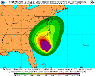 The most recent observations have Ana listed as a Tropical Storm based on categorizing criteria, however the Ana is named "Subtropical" due to it's cold core nature. Hurricanes and other large rotating tropical systems (Typhoons, Storms, and Depressions) all have a warm core, meaning that the temperature in the center of the storm is warmer than that on the outskirts, and warm air is advected, or forced in a particular direction, toward the center of the storm where it rises and allows for the stretching of the column and enhanced rotation. With this cold core nature, however, the influx of new air is from the upper atmosphere where there is convergence, so the air is much cooler in the eye than it is even in the eye wall where the warm tropical Atlantic waters are providing moisture.
Below is a rundown of current conditions and my forecast for Wilmington/Wrightsville Beach, NC. All of the information can be found on the National Hurricane Center website at http://www.nhc.noaa.gov/
| 8:00 PM EDT Fri May 8 Location: 31.9°N 77.3°W Moving: Stationary Min pressure: 1000 mb Max sustained: 45 mph | |||||||

Tonight 11 pm - midnight: Showers possible
Tomorrow 7:00 am - 10:00 am: Rain will continue broken due to outer rain band
Tomorrow Noon - 4:00 pm: Another outer rain band will produce heavier precipitation
Sunday midnight - 3:00 am: A third rain band will make its way on shore
Sunday 4:00 am - 5:00 am: The storm will be making its debut as the outer wall makes landfall
Sunday 10:00 am: The eye should make landfall. Heavy rain should continue for the remainder of the day into the overnight hours due to slowness of northward propagation.
Monday - The back side of the storm will continue to dump rain into the late morning/early afternoon as Ana continues to move northnortheastward.
If anyone has any questions about their specific location, go ahead and post on my facebook page found here: https://www.facebook.com/miscan5000?ref=aymt_homepage_panel. I would be happy to answer questions about what the weather will be like in different locations across the state!
Thursday, May 7, 2015
Tropical Season before Tropical Season
Summer (Break) has arrived for many college students across the United States, and this is a much-needed break for many people I know. However, work never ends. Fortunately for meteorologists, work and play are synonymous. Forecasters in both KILM (Wilmington, NC), KCLX (Charleston, SC), KJAX (Jacksonville, FL) and KAMX (Miami, FL) have been working very hard in an attempt to accurately forecast the possible formation and propagation of what may be our first named storm of the season, which will actually form before the season that doesn't even officially begin until June 1!
 Currently the National Hurricane Center has the map marked that there is greater than a 60% chance of tropical cyclone formation, and it sure is beginning to act like a TC in with respect to numerous factors: warm core system, upper level low atop surface low in the short-range trough, strong uniform counterclockwise rotation, and rain bands beginning to form along the coastal fronts associated with the system. SC and GA are being affected currently, and SE NC should feel the effects of this storm over the weekend. Due to an El Nino event climatologically, this year is expected to be a less active tropical year than years past. However, if conditions are favorable, climate does not always drive the weather, and specific events like tropical cyclones are able to form even if climate suggests otherwise.
 In addition, severe weather is really kicking up in the midwest. Yesterday and last night, a line of severe tornadic supercell thunderstorms moved through Oklahoma, causing far more than just wind damage. Tornadoes ripped apart structures, but flooding also "uprooted" homes and other structures which were never meant to leave the ground, like Storm Shelters. This image to the right is that of a storm shelter (by @KOCOdamonlane sent to Moore Oklahoma Tornado Recovery page on Facebook) which was displaced from its location in the ground due to the flooding of the water tables. Unfortunately, there was one death associated with these storms, and the ironic thing about it is that the individual died in a flooded storm shelter. Another interesting story is that loosed animals from the Tiger Safari Zoo in Tuttle, Oklahoma, have all been accounted for. Yes, Tigers were on the loose for some number of hours.
Unfortunately this is all the time I have for right now. I am going to try to post more often this summer. I hope everyone has a fantastic summer and is able spend some time soaking up the Vitamin D!
Friday, April 3, 2015
Natural/Supernatural Events on Good Friday
Well it may still be
winter up North, but Spring has more than arrived in the Southeastern United
States. Temperatures in Florida are in the upper 80's, 70's-80's in GA and the
Carolinas, and 70's in MI and AK. What is even better for meteorologists is the
beginning of the convective storm season! Convective thunderstorms have begun
forming along frontal boundaries in the past week, and we have even experienced
a tornado in Moore, Oklahoma.
This post, however, is
more for the meteorological and geological events surrounding the Crucifixion
of Jesus on this day, some 2,000 years ago outside of Jerusalem on the Hill of
Golgotha. The Gospels of Mark and Matthew report a few events which I will now briefly discuss:
1. Darkness: Jesus was
crucified between the hours of noon and 3:00 in the afternoon. As He was dying
on the cross to take on and forgive the sins of the world, a darkness fell over
the Earth. Many Greek Scholars believe this to have been a complete solar
eclipse, though some believe it to be miraculous. The Crucifixion took place
during the time of Passover, which in the Jewish Calendar always fell on or
near a full moon. The miraculous nature of this event resulted in the fact that
a complete solar eclipse can only occur during a new moon.
2. Earthquakes: "50 And
Jesus cried out again with a loud voice, and yielded up His spirit. 51 Then,
behold, the veil of the temple was torn in two from top to bottom; and the
earth quaked, and the rocks were split, 52 and the graves were
opened; and many bodies of the saints who had fallen asleep were raised; 53 and
coming out of the graves after His resurrection, they went into the holy city
and appeared to many.
54 So when the centurion and those with him, who
were guarding Jesus, saw the earthquake and the things that had happened, they
feared greatly, saying, 'Truly this was the Son of God!'" (Matthew
27:50-54, NKJV)
3. Rising of the Dead:
Jesus, under His own power as God, rose from the dead and conquered the grave
on the third day (Easter Sunday). However, many others were raised from the
dead during the time of his Death just a few days earlier. As is written in the
passage quoted above, graves were opened and the bodies (of those who followed
Christ while He was on the earth who had died) came out of the grave and
witnessed to those in the city.
These three signs, two of which are natural, one of which is supernatural, all occurred on the same day at roughly the same time. It is a miraculous combination of events which have only been experienced during the death of Christ on the cross. Whether you believe in God or not, this is amazing.
Monday, February 16, 2015
2015 "Ice Storm" Forecast
 It's the end of the weekend and the weather is moving in. This is what we've all been waiting for! So, like I was saying in my post yesterday, in order to get snow, we need to be on the northern side of the 540-line. Unfortunately for the system tomorrow, it looks as though we will have temperatures aloft that are too warm for the development of snow. It looks like around the 1-2 km level in the atmosphere will be above freezing, meaning frozen precipitation will melt before it refreezes in the surface layer. The primary precipitation for Raleigh, NC will be sleet/freezing rain, and much less snow than we were initially expecting. Though, it looks as though we will still get between 2-4 inches of accumulation over the next 48 hours.
I have noticed a lot of brine solution on the road today as I have been driving around Wake Forest, Raleigh, Cary, and Apex. I am glad to see that NC is preparing, but I fear that it may not do much good with the precipitation coming in.
Tuesday
Here is a rundown for each day:
Monday
Temperatures will be cold and winds will still be whipping on Monday morning and afternoon, and it looks like winter precipitation will start falling as a snow/sleet mix around 5:00-6:00 Monday night. It will be light at first, but after midnight precipitation will really begin falling. Accumulation looks to be around 1" of sleet/snow/freezing rain on Monday overnight.
 |
| WRAL winter potential |
Tuesday
Wind will be breezy and temperatures more mild. The temperature on Tuesday morning will be around 25 and will increase to around 33, though that extra degree above freezing most likely won't have much of an effect on melting the precipitation. Freezing rain and sleet will likely be the scenario before lunch, but after lunch it will be primarily snow again for a few hours before clearing out. All in all, we should see between 2-4 inches of precipitation in Raleigh.
Wednesday
We will not likely have any precipitation on Tuesday night or Wednesday, but the temperature is going to stay below freezing, and as a matter of fact the low on Wednesday night is possibly going to be in the single digits depending on the how the wind calms down and how the clouds clear out. Any precipitation, frozen or liquid, on the roads and grass will refreeze on Wednesday night.
Now for what everyone is waiting for.
Class Cancellation Forecast
Nothing is definite yet, but I would presume based on prior years of experience with University closings that...
Class Monday night - gym closes early, classes after dinner cancelled
Class Tuesday - Cancelled all day
Class Wednesday - Morning cancelled, classes after 12 noon may still occur
Class Thursday - This is a stretch 4 days out, but IF there is any precipitation still left on the ground Wednesday night, it will refreeze and classes before noon on Thursday will be cancelled.
Word to the wise, I would still prepare for afternoon classes Wednesday and all classes Thursday in case they are still held. It is more likely that we have them than not.
What To Watch Out For
1. Wintry precipitation. Monday night I would put your windshield wipers up so that they do not get frozen to the windshield. If your business is still open on Tuesday, be aware that you will need to start your car earlier because it will be frozen shut
2. Black ice. If you HAVE to go out on Tuesday, drive slowly and carefully. Bridges WILL be frozen, even with the brine solution on the road.
3. Power Outages. Yes, Power Outages. With freezing rain in the amounts the models are saying, this is a very real concern for especially Southern and Eastern North Carolina.
Hope this helps! Everyone please stay safe over the next few days! Remember, if forecasts are off from any forecasting site, including my amateur forecast here, forecasting winter weather anywhere, but especially in NC, is VERY difficult because of the number of factors which affect both amount and type and the slight changes between each. This is NOT going to be a massive snow event like we had in 2000, or a crazy crippling ice event like we had in '04. This next 48 hours is going to be a messy winter weather period. Stay tuned to your local stations!
Saturday, February 14, 2015
Winter Has Finally Arrived!
I realize this title is a little misleading and would seem uneducated, so allow me to explain: Winter has finally arrived in Raleigh, NC. Finally the 10-day, then 7-day, and now 3-day model runs of the European Model are in line with the American models with enough confidence to create a forecast preparing the general public for the Triangle's first winter storm of the season.
This season has been a wetter, and colder winter than average, yet we have not seen ANY wintry precipitation in the triangle aside from a couple of flurries. Why? Well, conditions have to be so perfect for a winter storm event, especially a snow event, that we just don't typically see them around central NC. What are those conditions? I have explained them directly below. If you just want to know the "What" and "When", then you can scroll down to the "Outlook" section. The "How" is the most important part to me so I threw it in here!
Cold pool at the surface: Typically, cold air at the surface in Central NC is established by a cold air damming event. As high pressure sets up over the NE United States and a Low centers over the Gulf states, warm air backs up on the western side of the Appalachian Mountains and cold Canadian air is funneled down the East side. This very cold pool of air, however, is not very deep, only typically about 1-1.5 km thick from the surface, but depending on where the high and low pressure centers are located, the pool can extend from the mountains all the way out to the Greenville and Fayetteville. When this happens, warm air and moisture are advected above the cold pool by a southeasterly or easterly wind (from the Atlantic Ocean). This moisture then falls into the cold layer, freezes, and falls to the surface.
Pressure Center Locations, Pressure Gradient: The best case scenario for that strong cold pool at the surface is a high pressure center located over the Great Lakes/NY/PA and a Low over the Gulf/Gulf states. When the pressure centers orientate as such, a strong East-West pressure gradient establishes itself over the mountains. Winds generally flow along the pressure gradient with low pressure to their left, but when this setup occurs cold Canadian air is forced rapidly in a clockwise direction around the high and shot downward into the Carolina's and Virginia's. Another atmospheric force, which is proportional to the magnitude of the wind speed, is a force vector which pulls the wind to the right in the Northern Hemisphere (direction is based on the planetary vorticity - to the right in the Northern Hemisphere, and to the left in the Southern Hemisphere). As the wind is shot southward, the Coriolis Force pulls the advected cold air into the Appalachian Mountains, and it begins to get blocked. After a couple days of blocking, the cold pool (mentioned above) finishes developing and is henceforth maintained.
Presence of Moisture: The timing of moisture advection into the cold pool is crucial to the development of wintry precipitation. If the moisture is advected after the cold pool has been eroded or before it is established, it will only rain.
Atmospheric Thickness: The thickness of the atmosphere is also an important parameter to look at when forecasting winter weather. Meteorologists have what is called the 540-line. 540 is the thickness of the 1000 millibar to 500 millibar pressure levels and is measured in decameters. Atmospheric Thickness is determined by the temperature of the air in that layer, and generally at 540 decameters the atmosphere is cold enough for the production of wintry precipitation.
The main problem with NC during the winter is that behind a cold frontal passage, the cold air makes it into the Piedmont, but the moisture typically gets blocked by the mountains as it moves from the Northwest to the Southeast.
Outlook: We do not have the pressure center locations currently that I specified above, but we have moisture being advected into cold air. The main event will not occur until Monday night, but currently we have snow report all across the state from Durham to accumulation in Boone.
The front is moving through tonight. Temperatures are going to get bitterly cold, dropping from the current 50 degrees to a low of 16-17 within the next 10 hours. It will be windy through the night with sustained winds in the 20's and gusts possibly reaching and topping 50 mph!
There are good chances for blowing light snow tonight along with this front because we have biting cold air aloft and decent moisture present. After timing analysis, it looks like the real wintry precipitation will begin early in the afternoon (about 1-2 pm) on Monday, but I will have another post tomorrow evening with more details about the event (this post is primarily for background). Precipitation is going to consist of snow in the afternoon and overnight, snow/ice mix as temperatures reach freezing, then back to snow Tuesday night after the temperature drops below freezing again.
Class Forecast: Based on what I am seeing right now, there will likely not be class on Monday night (after 6 pm), Tuesday, Wednesday, or Thursday morning (before noon). There are a lot of factors going into that bold #Statement (I had to throw that in there, especially after our men's basketball team had such an awesome game against No. 9 Louisville earlier today), which is why I will write another post tomorrow which is more of a forecast (again, this post is analysis). It's going to be another "Snowpocalypse" in Central NC!
Things to Stay Aware of:
1. Be careful of wind. Powerlines could be taken down by trees or by the wind itself tonight and driving will be dangerous! If you can stay home overnight, stay home. It will also be very windy tomorrow, so if you will be driving on the interstate as I will be in the morning, keep two hands on the steering wheel and do NOT have any distractions while driving. Your car can be pushed into the shoulder very easily by the wind.
2. Be aware of temperatures. The low tonight is going to be in the mid teens and cold temperatures with strong winds make for a very quick loss of body heat. If you have to be outside for an extended period of time, BUNDLE UP!
3. Watch out for black ice. If you are in higher elevations or areas where precipitation is currently falling, and there is water on the road, it WILL FREEZE overnight. Temperatures have been consistently cold enough for ground temperatures not to hinder the freezing of precipitation as the air temperatures drop to 17 tonight.
That's all for now! Have an awesome and safe night! I will touch base again tomorrow!
Tuesday, January 6, 2015
With Bowl Games and Semi's out of the way, winter weather is here to stay!
After a seemingly warm December for the Southeastern and Southern United States, it seems as though a shift in temperature is in order. Out with the old and in with the New Year, but the old weather is still the current weather (I would say it doesn't change...but let's be honest, weather is ALWAYS changing). A cold blast is affecting the United States and in addition to already frigid temperatures, wind chill temperatures are such that would seemingly crack frozen hairs off your head.
Raleigh
 Let's start with Raleigh and work our way colder. Raleigh is experiencing the warmest day of the surrounding week today with a forecasted high temperature of 52. Temperatures will drop and stay cold in the next couple days as a result of the first and second cold blasts which we will experience, one yesterday, and one later this week. For the first day of classes tomorrow, it's going to be cold during the day and especially cold at night. Tomorrow morning for our 8:00 classes, the temperature will be situated around 30 F. The high forecasted for tomorrow is in the upper 30's, but tomorrow night the temperature will drop into the 10's (11-12 degrees) with wind chill values near 0 as a result of a strong northwesterly wind sustained from 15-20 mph with gusts reaching 30.
This also means that if you have an 8:00 or 8:30 class on Thursday morning, those are the temperatures that we are going to be experiencing on our way to class. my only advice is to bundle up and have chap stick with you so that your lips don't get wind burned and chapped.
 Thursday night for morning classes on Friday the temperature will be much more mild and manageable with temperatures sitting in the upper teens (I know, still very cold, but much warmer than 0). Friday temperatures should climb back into the low 40's with sunny skies and calm winds.
This weekend will be cool but consistent. Low temperatures Friday night/Saturday morning will be around 20, the high Saturday will be near 40 with mostly sunny skies, the low on Saturday night/Sunday morning will settle around the mid 20's, and Sunday afternoon the high will reach the low 40's again with mostly cloudy skies and decent potential for an afternoon or evening shower across the Piedmont.
United States
The rest of the northern United States will experience cold temperatures, but not in the sense that we think cold. They will experience frigid temperatures over the next few days; 30 below 0 frigid. Yes, you read that correctly. With this second cold blast, the Northern Plains will experience the coldest temperatures with wind chill values of -50 in some areas of northern Minnesota and -40 around the great lakes, and as the Jet stream continues to move south, the New England States and eastern portions of the Great Lakes will experience the coldest temperatures with -30's wind chill in Chicago and -40 wind chill in northern Maine. Now, I've only heard of school closing as a result of cold temperatures a couple times in the short life that I have lived so far, but I'd have to say that if classes were to be cancelled for such a reason again, this would be a good time to do it in the Northern United States.

Meteorological Breakdown
So what is allowing these frigid temperatures to occur in the United States? I'm glad you asked. The jet stream, though it does not have the final say on Micrometeorology and Mesoscale Meteorology, has quite an effect on the temperatures which we experience. It creates a figurative wall between the cold northern Canadian air, and the warm southern Gulf air. As the jet stream shifts, so do the temperatures. The first cold blast is hit last night and today, but as the second cold blast affects temperatures over the next couple of days, the jet stream moves from a centralized location of around Maryland and Northern Virginia, to the southern states after dipping down in the Midwest. Also due to the location of the jet stream, very little Pacific or Gulf moisture will be entrained into this cold pocket and clouds that form will be very icy in nature allowing for maximum sunlight reflection meaning that temperatures will stay cool for some time. I'll be interested to see how much wintry precipitation occurs in the North with this second cold blast. NY has already experienced another significant lake-effect snow event which dumped about 2 feet in some places in central NY.

I know that in the last couple of days, especially last night, significant snow fell in regions of Maryland (Washington D.C. as well), Ohio, northern Virginia, and Indiana and more snow is expected to fall in these areas and north with the passing of what the Weather Channel is naming Winter Storm Gorgon. I have been following the Weather Channel's and the NWS's twitter feeds in order to stay updated on most recent meteorological turn of events regarding precipitation, temperatures, and human impact whether it be travel conditions or flight delays and cancellations.
Impact of "Winter Storm Gorgon"
It is estimated that over 240 million people in the United States will be affected, whether it be cold temperatures, winter precipitation, cancelled/delayed flights, packages and shipments being delayed, or even not being able to drive home. I hope there are no power outages because especially with temperatures this cold, power outages could be fatal. I don't want to see any deaths from this winter storm and blast of cold air. Last night over 500 flights were delayed to/from Chicago O'Hare International Airport and more will be delayed if not cancelled tonight as a result of the continued battering of wind and frigid temperatures. Stay tuned to your local weather stations for information in your area regarding this winter storm.
Going Outside?
If you have to go outside for any reason, bundle up. If temperatures in your area with wind chill are getting to be in the teens below zero or lower, make sure that any exposed skin is covered up. Wearing two pairs of gloves and socks is not a bad idea in order to protect your extremities. Keep moving in order to help your heart pump blood to your entire body, and keep wiggling your fingers and toes in order to keep blood flowing through the smaller blood vessels in your body. Have chap stick with you so that you can protect your lips from the wind and precipitation. Wearing two hats and two shirts underneath a heavy jacket and a/or thermal shirt is a good idea to protect your core and prevent heat loss from the top of your body (where most of body heat is lost). Don't go outside unless you absolutely have to. The combination of wind and precipitation dehydrates skin very quickly so be sure very little to no skin is exposed.
It's going to be a cold next couple of months in the Central, Northern, and Eastern United States. This is one of many expected winter storms and Canadian cold blasts to affect our region so get ready for consistently colder temperatures over the next couple months.
Happy New Year!
Raleigh
This also means that if you have an 8:00 or 8:30 class on Thursday morning, those are the temperatures that we are going to be experiencing on our way to class. my only advice is to bundle up and have chap stick with you so that your lips don't get wind burned and chapped.
Thursday night for morning classes on Friday the temperature will be much more mild and manageable with temperatures sitting in the upper teens (I know, still very cold, but much warmer than 0). Friday temperatures should climb back into the low 40's with sunny skies and calm winds.This weekend will be cool but consistent. Low temperatures Friday night/Saturday morning will be around 20, the high Saturday will be near 40 with mostly sunny skies, the low on Saturday night/Sunday morning will settle around the mid 20's, and Sunday afternoon the high will reach the low 40's again with mostly cloudy skies and decent potential for an afternoon or evening shower across the Piedmont.
United States
The rest of the northern United States will experience cold temperatures, but not in the sense that we think cold. They will experience frigid temperatures over the next few days; 30 below 0 frigid. Yes, you read that correctly. With this second cold blast, the Northern Plains will experience the coldest temperatures with wind chill values of -50 in some areas of northern Minnesota and -40 around the great lakes, and as the Jet stream continues to move south, the New England States and eastern portions of the Great Lakes will experience the coldest temperatures with -30's wind chill in Chicago and -40 wind chill in northern Maine. Now, I've only heard of school closing as a result of cold temperatures a couple times in the short life that I have lived so far, but I'd have to say that if classes were to be cancelled for such a reason again, this would be a good time to do it in the Northern United States.
Meteorological Breakdown
So what is allowing these frigid temperatures to occur in the United States? I'm glad you asked. The jet stream, though it does not have the final say on Micrometeorology and Mesoscale Meteorology, has quite an effect on the temperatures which we experience. It creates a figurative wall between the cold northern Canadian air, and the warm southern Gulf air. As the jet stream shifts, so do the temperatures. The first cold blast is hit last night and today, but as the second cold blast affects temperatures over the next couple of days, the jet stream moves from a centralized location of around Maryland and Northern Virginia, to the southern states after dipping down in the Midwest. Also due to the location of the jet stream, very little Pacific or Gulf moisture will be entrained into this cold pocket and clouds that form will be very icy in nature allowing for maximum sunlight reflection meaning that temperatures will stay cool for some time. I'll be interested to see how much wintry precipitation occurs in the North with this second cold blast. NY has already experienced another significant lake-effect snow event which dumped about 2 feet in some places in central NY.
I know that in the last couple of days, especially last night, significant snow fell in regions of Maryland (Washington D.C. as well), Ohio, northern Virginia, and Indiana and more snow is expected to fall in these areas and north with the passing of what the Weather Channel is naming Winter Storm Gorgon. I have been following the Weather Channel's and the NWS's twitter feeds in order to stay updated on most recent meteorological turn of events regarding precipitation, temperatures, and human impact whether it be travel conditions or flight delays and cancellations.
Impact of "Winter Storm Gorgon"
It is estimated that over 240 million people in the United States will be affected, whether it be cold temperatures, winter precipitation, cancelled/delayed flights, packages and shipments being delayed, or even not being able to drive home. I hope there are no power outages because especially with temperatures this cold, power outages could be fatal. I don't want to see any deaths from this winter storm and blast of cold air. Last night over 500 flights were delayed to/from Chicago O'Hare International Airport and more will be delayed if not cancelled tonight as a result of the continued battering of wind and frigid temperatures. Stay tuned to your local weather stations for information in your area regarding this winter storm.
Going Outside?
If you have to go outside for any reason, bundle up. If temperatures in your area with wind chill are getting to be in the teens below zero or lower, make sure that any exposed skin is covered up. Wearing two pairs of gloves and socks is not a bad idea in order to protect your extremities. Keep moving in order to help your heart pump blood to your entire body, and keep wiggling your fingers and toes in order to keep blood flowing through the smaller blood vessels in your body. Have chap stick with you so that you can protect your lips from the wind and precipitation. Wearing two hats and two shirts underneath a heavy jacket and a/or thermal shirt is a good idea to protect your core and prevent heat loss from the top of your body (where most of body heat is lost). Don't go outside unless you absolutely have to. The combination of wind and precipitation dehydrates skin very quickly so be sure very little to no skin is exposed.
It's going to be a cold next couple of months in the Central, Northern, and Eastern United States. This is one of many expected winter storms and Canadian cold blasts to affect our region so get ready for consistently colder temperatures over the next couple months.
Happy New Year!
Subscribe to:
Posts (Atom)