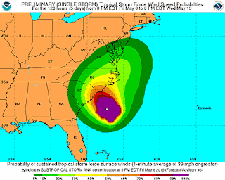
 The most recent observations have Ana listed as a Tropical Storm based on categorizing criteria, however the Ana is named "Subtropical" due to it's cold core nature. Hurricanes and other large rotating tropical systems (Typhoons, Storms, and Depressions) all have a warm core, meaning that the temperature in the center of the storm is warmer than that on the outskirts, and warm air is advected, or forced in a particular direction, toward the center of the storm where it rises and allows for the stretching of the column and enhanced rotation. With this cold core nature, however, the influx of new air is from the upper atmosphere where there is convergence, so the air is much cooler in the eye than it is even in the eye wall where the warm tropical Atlantic waters are providing moisture.
Below is a rundown of current conditions and my forecast for Wilmington/Wrightsville Beach, NC. All of the information can be found on the National Hurricane Center website at http://www.nhc.noaa.gov/
| 8:00 PM EDT Fri May 8 Location: 31.9°N 77.3°W Moving: Stationary Min pressure: 1000 mb Max sustained: 45 mph | |||||||
Tonight 11 pm - midnight: Showers possible
Tomorrow 7:00 am - 10:00 am: Rain will continue broken due to outer rain band
Tomorrow Noon - 4:00 pm: Another outer rain band will produce heavier precipitation
Sunday midnight - 3:00 am: A third rain band will make its way on shore
Sunday 4:00 am - 5:00 am: The storm will be making its debut as the outer wall makes landfall
Sunday 10:00 am: The eye should make landfall. Heavy rain should continue for the remainder of the day into the overnight hours due to slowness of northward propagation.
Monday - The back side of the storm will continue to dump rain into the late morning/early afternoon as Ana continues to move northnortheastward.
If anyone has any questions about their specific location, go ahead and post on my facebook page found here: https://www.facebook.com/miscan5000?ref=aymt_homepage_panel. I would be happy to answer questions about what the weather will be like in different locations across the state!


