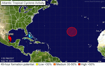
I just wanted to make a short post today about Hurricane Ingrid. Ingrid is currently moving West Northwest at 6 mph. She has max sustained wind speeds of 75 mph and as a Cat 1 her eye should be making landfall by 7:00 tomorrow (Monday) morning.
You can find the public weather advisory for Mexico at this link: http://www.nhc.noaa.gov/text/refresh/MIATCPAT5+shtml/151751.shtml
There is now a high chance of a tropical system forming in the Mid Atlantic over the next couple of days. I will keep all of you posted with that development as information is received from the models.
I would also like to inform all of you that Tropical Storm Manuel is working his way up the Central American coastline and will be dumping rain throughout the region over the next couple of days.
I hope everyone had a wonderful weekend and enjoyed this first taste of fall weather!


No comments:
Post a Comment