Friday, March 28, 2014

Spring Has Returned! And so has the Tornado Season

So, after winter tried to make a comeback last week, spring is moving it's way into the eastern seaboard. This weekend we will see rain and possible thunderstorms tomorrow as this trough moves through, but next week spring will be in full swing! Temperatures will be in the low 70s tomorrow and the upper 50s Sunday with mostly cloudy skies and rain.... not as much as we've experienced the rest of this year so far, but still rain nonetheless.

Starting Monday though? Spring. High temperatures in the 70s, maybe even reaching 80 by late next week, lows in the upper 40s and 50s, and partly cloudy to mostly clear skies. If you have some time to get outside next week, take advantage of it. I know that I will be getting on the tennis court and studying outside as much as I am able to next week.

Today is an interesting day in NC and SC history: it is the 30th anniversary of the most deadly tornado outbreak in the Carolinas. 30 years ago today, a total of 24 confirmed tornadoes raced through the Carolinas causing massive damages and extreme devastation to the population. The outbreak caused 57 deaths and 1248 injuries with 37% of the deaths occurring in mobile homes. Some of the tornadoes were moving across the ground as fast as 65 mph. Here is a link to the National Weather Service's page concerning the deadly outbreak: http://www.weather.gov/mhx/March281984Anniversary

Yesterday there was a line of severe thunderstorms that moved across Missouri. This system produced at least 1 tornado which moved along the ground for 6 miles in the Trenton area. Although this tornado damaged at least 4 homes, and rain and hail pelted NE Missouri throughout the day, no injuries have been reported. Storm shelters are being constructed in many public buildings throughout Tornado Alley, and the new Elementary School in Oklahoma City is building a storm shelter in preparation for the tornado season. http://kfor.com/2014/03/28/new-downtown-elementary-to-add-tornado-shelter/

If you all recall, last year was a heavy-hitting tornado kind of year. Moore, Oklahoma was pounded with the strongest tornado of the year by an EF-5 tornado which followed almost the same path of almost equal-strength tornado which also devastated Moore, Oklahoma on May 3, 1999. This tornado which occurred on May 20, 2013, killed 24 people and demolished 1,100 homes. Yesterday it was reported that students of Joplin, Missouri (which got nailed by an EF-5 tornado on May 22, 2011), are going to visit the students of the Elementary School in Oklahoma City. http://www.newson6.com/story/25089623/joplin-students-to-visit-moore-children-who-lost-school-to-tornado

Biggest Tornado News of Yesterday
Yesterday, an EF-1 tornado reportedly touched down and damaged homes in Northern California. That doesn't happen every day! Fortunately, although 12 to 20 homes had roof damage, no one was misplaced from their homes, and there were no injuries reported. Northern California finally got some rain though! parts of the state recorded up to 2". http://www.sfgate.com/news/article/Tornadoes-hit-Northern-California-damaging-homes-5355635.php#photo-6079979A funnel looms over Roseville, where a tornado touched down and left a dozen to 20 houses damaged. Photo: Handout, Reuters

For more Tornado News, visit this site: http://www.wxusa.com/tornadonews.htm
Tuesday, March 18, 2014

So Much Weather!

I am currently blogging from Miamisburg, Ohio! Aside from it being a bit chilly, skies are partly sunny and the hotel where I am staying has a basketball goal set up out front! Yesterday part of the NC State Pep Band and Cheerleading squad flew up to Dayton, Ohio with the NC State Men's Basketball team for a play-in game against Xavier for the No. 12 seed in the Big Dance! This is the third year in a row for the third year Coach Mark Gottfried to make the NCAA Men's Basketball Tournament and State fans and students are pleasantly surprised at how one of the youngest teams in the Nation far exceeded expectations this year. Not only is the Men's team dancing, but the NC State Women's Basketball Team under first year head coach Wes Moore was given the No. 5 seed in the West and will be traveling to Los Angeles later this week to face the 12 seeded BYU basketball team. Congratulations to both teams!!

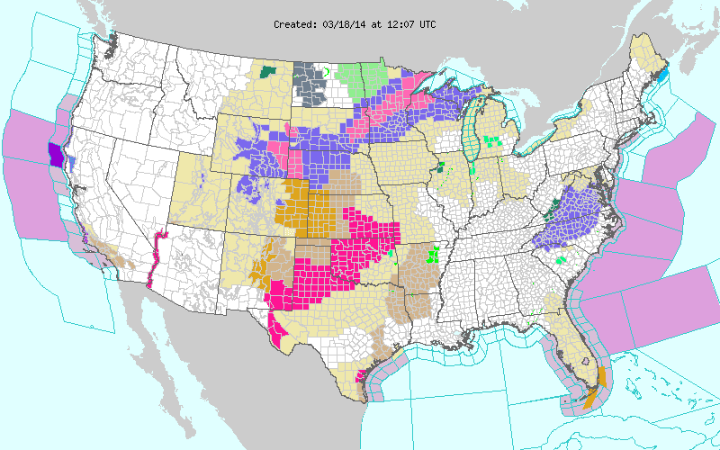
The next winter system to move through is the Midwest Clipper. Yesterday Meteorologists were watching a low pressure system moving over the Rocky Mountains. This clipper-like system is currently moving through the northern Midwest and places in northern Wisconsin and Minnesota could see up to one foot of snow. The system (not yet able to define it a clipper because it doesn't have all the characteristics of a clipper) will be moving eastward and southward over the next few days mainly affecting the the Great Lakes area and the northern portion of the eastern seaboard.

Well, the precipitation has moved out but the dangers are not over yet in Raleigh. Closings are prominent across central NC as schools are delayed or closed and road conditions are not favorable for driving. There have been many wrecks this morning so far but fortunately the sun is on the horizon...for a few days. The first day of Spring is this Thursday, March 20 and it will feel like Spring for the first 3 days of the new season. Thursday will have a high in the mid 60s, Friday in the upper 60s, and Saturday in the low 70s! Unfortunately this nice weather won't last for long as temperatures will cool off again when the Clipper system moves through the the Northeast.

Another dangerously interesting fact is that the Great Lakes earlier this year were over 92% covered with Ice. Today, after a couple of above-average days in Chicago and other major cities surrounding the Great Lakes, coverage is around 50%. Hydroelectric power, which powers numerous homes surrounding Niagara Falls, nearly had a power-freeze earlier this year with the St. Lawrence river being covered in ice and the large chunks of ice getting down into the power plant dams on both the U.S. and the Canadian sides of the falls.
http://www.wired.com/wiredscience/2014/03/great-lakes-frozen/

Finally, there are Red Flag warnings across the western Midwest as a wildfire continues to burn.

On a different note, today is the 89th anniversary of the most devastating tornado ever to move through the United States. the Tri-State tornado of 1925. This tornado plowed a straight path through Missouri, Illinois, and Indiana killing 695 unsuspecting people and flattening 15,000 homes. At this point in time the U.S. Weather Bureau (now the National Weather Service) didn't even have the word "Tornado" in their vocabulary because when used in the military back in 1887, the term "Tornado" meant a weather phenomenon that was impossible to predict that could wreak havoc on an unsuspecting town or city, and it caused the people to panic, so it was banned from the vocabulary of meteorologists. Here is a link with further description on the Tri-State Tornado:
http://www.popularmechanics.com/science/environment/natural-disasters/4219866

Sunday, March 9, 2014

Spring is now in full swing! After springing ahead last night with the clocks, the temperature also moves forward in the season! Temperatures in Raleigh today should reach 65 or 66 and even higher at 69-70! Skies mostly sunny with come intermittent clouds. Notice below how clear the southeastern United States is right now!

These conditions won't end soon either! sunny skies and warmer temperatures, aside from this weekend, will be prominent through the week. It looks as though the Piedmont, Sandhills, and Coastline of NC will experience temperatures in the upper 60s low 70s for the next few days. As a cold front moves through on Wednesday night to Thursday morning, temperatures will drop into the mid-upper 50s on Thursday and Friday, then back into the 60s this weekend.

I don't know about all of you, but I will be going to the beach, washing my car, and well, just spending a lot of time outside. By the way, I am on spring break this week. That's the only reason I am able to do the previous list.

I went with the NC State pep band this weekend to Greensboro to support the lady Wolfpack. A cold front/winter weather system moved through on Wednesday night and continued until Friday night. There were thousands of people without power, trees and power lines down due to ice, and ice and sleet packed up to about 3 inches thick on the ground. All of this is just about melted now and power is returning to residents of Greensboro.

Here are a couple pictures to get everyone in the spring/summer mood:


Saturday, March 1, 2014

What's up everyone! So, I realized that I only posted twice in February and I only posted about one of 2 major winter storms. Guess what. I HAVE TIME TO POST RIGHT NOW! This is the first time in the last 2 weeks that I haven't been rushing to finish a project, application, assignment, or study for a test. School is crazy right before Spring Break but today, Saturday 3/1, I finally have some time to post!

First of all, enjoy another taste of Spring tomorrow when you can! Tomorrow here in Raleigh the mercury should rise up into the upper 60's and the skies will be clear until after noon. In the early afternoon we should begin seeing upper-tropospheric clouds forming (Cirrus and forms of cirrus), but the sun will be unblocked through sunset. As the temperatures cool off ahead of the front, lower level clouds will fill the sky. Rain can be expected early Monday morning and should continue on Monday until the mid-Afternoon. At this time, the rain could turn to ice pellets/sleet continuing until about midnight or 1:00 A.M. on Tuesday.

After thoroughly examining the BUFKIT skew-T forecasts for the next few days, I would have to agree with the current forecast on WRAL. Although temperatures will not be cold enough for ice, temperatures at about the 950 hPa (950mb, ~500m) level, temperatures will be around -7 C, which is enough below freezing that most precipitation will not melt en-route to the ground, and the cold layer is thick enough that precipitation will be frozen solid.

Once the cold front moves through on Monday, temperatures will again drop to below normal for this time of year. The average temperatures throughout the week after Monday are looking around 47 for the highs and around 27 for the lows until next Saturday, 3/8. Next weekend we should see temperatures warm up a bit again as the massive Canadian High pressure system moves through off the coast and the Sub-polar jet moves further north.

Anyway, enjoy the spring weather tomorrow!