The tropics are alive and well as we have reached the peak of hurricane season, and it's not going to stop soon. Currently there are three named storms in the Atlantic basin: Hurricane Irma, Hurricane Jose, and Hurricane Katia. Hurricane Katia will spin up some moisture and head down into central Mexico providing some much-needed rain down there. I will discuss Irma and Jose further below.
Major Hurricane Irma
Hurricane Irma has been catching the nation's attention for almost a week now. Riding the wake of Hurricane Harvey, which just spent a week parked over southeast Texas dumping 7-day record-breaking rainfall totals of over 60" and producing catastrophic flooding, Irma has been forced on a more westward path, alerting the Caribbean and United States of the raw power of God's creation. Tuesday afternoon (18Z 20170906), Air Force Reconnaissance recorded wind data on their flight, including max sustained winds exceeding 185 mph.
The Caribbean Islands are experiencing Category 5 hurricane Irma now and the next island to receive a direct hit will be will be Haiti and the Dominican Republic. Some islands, including Barbuda and St. Martin, have basically been destroyed... In Barbuda, all cell phone towers have been knocked over, the reinforced steel bent and twisted from the strength of the winds.
One aspect of this storm to keep in mind is its relation to the Synoptic, or large-scale environment. High pressure building into the Great Plains is forcing Irma on a more westnorthwestward path, however as the trough ahead of it lifts out into the northern Atlantic, Irma is expected to make a sharp turn to the northnortheast. It has already begun heading more NW than earlier, and models now have major hurricane Irma running up the east coast, potentially making landfall in Miami on Sunday morning/afternoon.

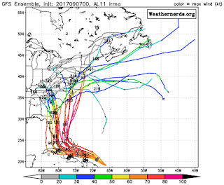
 Georgia and the Carolinas are currently in the line of sight for Irma, however northern Hispanola, the Bahamas, and Florida reside in the immediate path. Much destruction has already occurred in the Caribbean, and although Irma has weakened slightly, more is to be expected with the now max sustained 180 mph winds. I have pictured to the left the most updated ensemble projections for the path of Hurricane Irma of the ECMWF (European Model, top) and the GFS Ensemble (American long-range Model, bottom). Irma is expected to cut back, but even now the models are not sure where exactly it will go. Whatever the case may be, the Bahamas and South Florida need to be preparing for the worst. Below I have also shared NOAA's main points regarding the devastation capable of Irma.
Here's what to prepare for (Irma edition):
High winds: While flooding remains a threat, the strong wind capable of toppling buildings and tossing automobiles like matchbox cars is the real threat initially. Keep in mind, 180 mph is about how fast planes fly when landing or taking off. It is about three times that of highway speed, and this powerful wind is capable of moving/uprooting/toppling just about anything. Even if this storm weakens as it moves up the coast and veers toward the Carolinas, as some model runs would suggest, places like Asheville, NC could experience hurricane-force wind gusts exceeding 75 mph.
Flying debris: Piggybacking off of the high wind potential, debris will be carried by winds. These winds can be equated to those found in an EF-4 tornado, which tends to flatten anything in it's path. The straight-line winds in a hurricane do not have quite the devastating effect of those found in an EF-4 solely because the pressure differential is much greater in a tornado, because it is a smaller cyclone of rotation, but nevertheless the winds can flatten structures and fling debris through the air with ease.
 Power outages: Cause and effect from the first two potential hazards leads us to the third hazard to prepare for, and that is widespread power-outages. While Irma will likely move quickly up the coast, the sheer strength of the storm will blow over power lines and possibly even ruin substations and power stations depending on their location... In this case, millions of people could lose power for an extended period of time while power companies work extra overtime in order to get everyone back on the grid. Make sure you have supplies prepared in the event of extended power outages.
Flooding: The final hazard I want to rehash is the possible of catastrophic flooding. This storm will not park itself over one location for a week as did Harvey, but the strength of the wind will cause massive storm surge along the coast, especially between Charleston and Wilmington should the current path come to fruition, and heavy rainfall further inland will flow down the narrow river basins overrunning banks potentially flooding downstream neighborhoods as we saw with Hurricane Matthew last year.
Hurricane Jose
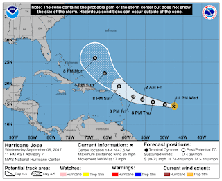
 Even just 24 hours ago, Jose was "supposed" to be a fish storm and curve back out to sea. Mother nature had a different idea in mind. The prevailing easterlies are proving to be an effective mode of transportation for Hurricane Jose, and now it is expected to take a more northwestward path. The danger now lies with the northern Caribbean islands which just got decimated by Hurricane Irma... and that danger is that another Hurricane will be making its visit in likely before the end of the weekend. There are reports that 90% of structures and automobiles have been destroyed on the Island of Barbuda, and now there is a possibility of another Hurricane, possibly Major Hurricane, wreaking additional havoc less than a week later. Hurricane shelters and other shelters alike were demolished from the record-breaking winds of Irma, and now another storm poses a threat to the Caribbean.
Essentials
Below is a list of items which would be necessary for survival should the above situations occur, those including flooding, widespread power outages, and wind damage.
1. Bottled Water
2. Canned Foods
3. Flashlight with extra batteries
4. External Phone Charger/Battery Pack
5. Some means of receiving updated information in the event of a power outage (i.e. phone, battery-powered weather radio, etc.)
6. Tent, sleeping bags, and other essentials for sleeping outdoors should residential structures become damaged to a point of endangering those residing in them.
7. Safe location away from the coast/coastal waterways
Not all of these may be possible, but now that NC and SC are both in a state of emergency, I highly recommend taking the necessary steps to prepare yourself and your loved ones for the worst, obviously praying and hoping for the best. The death toll has begun in Barbuda with already 6 people being proclaimed dead, and that number will only rise as conditions clear behind the storm ahead of Jose and damage can be assessed. Please do not take this storm for granted, as it is a life-threatening storm capable of catastrophic damage.


No comments:
Post a Comment