Fantastic weather here in the Triangle, especially for game day! Today's High it around 80 with a low in the upper 50s tonight and variably cloudy skies throughout the day. Humidity should be at comfortable levels again today as well. It looks as though this weather will continue for a couple of days too as rain is not showing up in the models until about Sunday afternoon.
An interesting observation for this post is that there are numerous counties in the West, located in the Rockies, that are under freeze watches/warnings and frost advisories.
Tropical Activity:
There is not too much going on right now. Hurricane Manuel, now a Cat 1, is still moving up the Mexican coast toward California.
Tropical Depression Humberto is still moving to the north in the Atlantic Ocean and may be dying out soon.
There is about a 70% chance of a storm forming in the southern Gulf of Mexico and about a 10% chance of a tropical cyclone forming in the Bermuda Triangle within the next 48 hours.
Thursday, September 19, 2013

Sunday, September 15, 2013
I just wanted to make a short post today about Hurricane Ingrid. Ingrid is currently moving West Northwest at 6 mph. She has max sustained wind speeds of 75 mph and as a Cat 1 her eye should be making landfall by 7:00 tomorrow (Monday) morning.
You can find the public weather advisory for Mexico at this link: http://www.nhc.noaa.gov/text/refresh/MIATCPAT5+shtml/151751.shtml
There is now a high chance of a tropical system forming in the Mid Atlantic over the next couple of days. I will keep all of you posted with that development as information is received from the models.
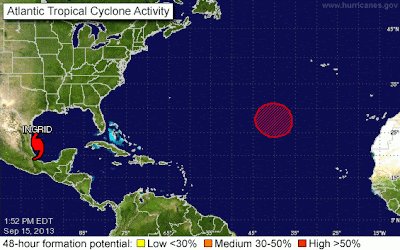
I would also like to inform all of you that Tropical Storm Manuel is working his way up the Central American coastline and will be dumping rain throughout the region over the next couple of days.

I hope everyone had a wonderful weekend and enjoyed this first taste of fall weather!
You can find the public weather advisory for Mexico at this link: http://www.nhc.noaa.gov/text/refresh/MIATCPAT5+shtml/151751.shtml
There is now a high chance of a tropical system forming in the Mid Atlantic over the next couple of days. I will keep all of you posted with that development as information is received from the models.

I would also like to inform all of you that Tropical Storm Manuel is working his way up the Central American coastline and will be dumping rain throughout the region over the next couple of days.

I hope everyone had a wonderful weekend and enjoyed this first taste of fall weather!
Thursday, September 12, 2013
Ladies and Gentlemen, welcome to hurricane season!
It's been a pretty slow season this year up until the last couple of days:
- Hurricane Humberto gained strength a couple days ago and is moving a little faster to the north into the southern mid-Atlantic as a Cat 1 with max sustained winds at 75 knots (~86 mph). Forecasts are showing that Humberto will be weakening over the next couple of days and will return back to a tropical storm late Friday night. For more information on Hurricane Humberto visit the National Hurricane Center's web site: http://www.nhc.noaa.gov/.

- Tropical Storm Gabrielle is taking center stage! The offshore waters of the Western Atlantic are under a Tropical Storm Warning! Tropical Storm Gabrielle is moving up the coast offshore and is taking it's time to stir up the Northwest Atlantic. There are currently no coastal watches or advisories but watercraft in the area should be careful. The center of Gabrielle was last located near [latitude 33.9 north, longitude 67.7 west] with max sustained winds at 35 knots (40 mph) extending outward up to 105 miles. She is moving north northeast at about 7 knots (8 mph) and will be speeding up and weakening over the next few days. For more information on Hurricane Humberto visit the National Hurricane Center's web site: http://www.nhc.noaa.gov/.

- May I also inform you that there is a 60% chance of a tropical cyclone developing in the Gulf of Mexico over the next couple of days. The upper level jet stream is way north near the great lakes so the air is relatively static near the Gulf. Only some 17-25 kt easterlies will be experienced in this region over the next couple of days allowing for moisture to gather in the atmosphere.
US Forecast
Raleigh is going to be experiencing some wonderful early fall weather this Saturday as the high is only supposed to reach the mid 70s. For the rest of Thursday into Thursday night there are possible isolated to widely scattered thunderstorms for the area.
Many of the New England States are under a severe thunderstorm watch right now and these could develop into warnings over the next 24 hours with the effects of Gabrielle and the Low Pressure System that is moving through.
Careful of flooding out in the West! Flash flood watches in effect for about 2/3 of the counties of New Mexico and much of Arizona, Nevada, Utah, Idaho, and Colorado as the front passes to the east.
It's been a pretty slow season this year up until the last couple of days:
- Hurricane Humberto gained strength a couple days ago and is moving a little faster to the north into the southern mid-Atlantic as a Cat 1 with max sustained winds at 75 knots (~86 mph). Forecasts are showing that Humberto will be weakening over the next couple of days and will return back to a tropical storm late Friday night. For more information on Hurricane Humberto visit the National Hurricane Center's web site: http://www.nhc.noaa.gov/.

- Tropical Storm Gabrielle is taking center stage! The offshore waters of the Western Atlantic are under a Tropical Storm Warning! Tropical Storm Gabrielle is moving up the coast offshore and is taking it's time to stir up the Northwest Atlantic. There are currently no coastal watches or advisories but watercraft in the area should be careful. The center of Gabrielle was last located near [latitude 33.9 north, longitude 67.7 west] with max sustained winds at 35 knots (40 mph) extending outward up to 105 miles. She is moving north northeast at about 7 knots (8 mph) and will be speeding up and weakening over the next few days. For more information on Hurricane Humberto visit the National Hurricane Center's web site: http://www.nhc.noaa.gov/.

- May I also inform you that there is a 60% chance of a tropical cyclone developing in the Gulf of Mexico over the next couple of days. The upper level jet stream is way north near the great lakes so the air is relatively static near the Gulf. Only some 17-25 kt easterlies will be experienced in this region over the next couple of days allowing for moisture to gather in the atmosphere.
US Forecast
Raleigh is going to be experiencing some wonderful early fall weather this Saturday as the high is only supposed to reach the mid 70s. For the rest of Thursday into Thursday night there are possible isolated to widely scattered thunderstorms for the area.
Many of the New England States are under a severe thunderstorm watch right now and these could develop into warnings over the next 24 hours with the effects of Gabrielle and the Low Pressure System that is moving through.
Careful of flooding out in the West! Flash flood watches in effect for about 2/3 of the counties of New Mexico and much of Arizona, Nevada, Utah, Idaho, and Colorado as the front passes to the east.
Friday, September 6, 2013
Central North Carolinians can expect more consistent weather this weekend and through the beginning of next week. Temperatures will be fluctuating a little bit throughout the next few days. Highs will be staying in the mid to upper 80s and partly cloudy conditions will ensue the Piedmont region. This is perfect weather for this weekends game for the Wolfpack against the Richmond Spiders!
http://www.wral.com/weather/7day/
![[Image of 5-day forecast and coastal areas under a warning or a watch]](https://lh3.googleusercontent.com/blogger_img_proxy/AEn0k_tXtdabyqwrw9_bW-j-g7XiGUZENDqiaSKx8l3GpS7EB6oe7NSwbDVGTiWk_NFJeVDQw23irKlVSs8WzKY-3UY0mQKkx65Z84BeJLg9wJdlVSRUDUf6k0UkUSlefQ3HjS-PL5zk3Mw6sEWSqc8BvbCS43kSmmISzNzb81RaGg=s0-d)
![[Image of probabilities of tropical storm force winds]](https://lh3.googleusercontent.com/blogger_img_proxy/AEn0k_u8VVmD-1j4Gd1x46zrAAZ767pOL-6b_UQJxOh7J-XPPS_jdy7RsUgvmPIvccki7e9ASo3pfWLYF1z-x-TDDmQQc12r-TMH7wE6oD6jeok0ReDRMPkrirEK-qD3f1T-gbBezWi4H50FaP3RwBKufbZW9FA7Zp_L65F1QRYi=s0-d)
Heat advisories are in effect for most of the Dakota counties. Also, there is an air quality alert for the Dallas/Fort Worth Texas region.
As patterns have changed over the past couple of weeks, rain has come to the Northwestern US. There are many counties in Washington State and Oregon that are experiencing heavy rain and are under flood watches. Alaska also has a few advisories. Anchorage is under a flood advisory and most of the coast between Anchorage and Dutch Harbor is under a storm advisory with forecasted winds between 30 and 40 knots (26-35 mph) and seas of about 13 feet.
Tropical Activity!
Gabrielle is still dumping rain on Puerto Rico and the U.S. Virgin Islands. There is also a low chance of a tropical storm forming in the Atlantic.
New storm categorized as a Tropical Storm, Tropical Storm Lorena, is formed in the Eastern Pacific and is currently approaching Baja, California.
Thursday, August 29, 2013
We had much better weather today in the triangle than was forecasted. The potentially inclement weather moved around the triangle and the rain fell elsewhere.
Tonight we should have fair and mild weather with isolated showers. Weather is looking very promising for the first half of the weekend! Perfect weather for the opening game of Wolfpack football! Friday should be mostly sunny and less humid with a high of around 86, and Saturday should be mostly cloudy with a high around 88 and a bit more humid than Friday. WRAL's forecast for Sunday? Cloudy with a chance of meatballs... not really. It's "Partly sunny, hot and humid with scattered afternoon storms." So, as students and families are getting geared up for fall, here comes the normal summer weather.
There is currently a severe weather statement in effect for the Southwestern United States, and a tornado watch in effect for the northern half of Wisconsin.
There is finally more of a tropical update for this unusually slow hurricane season! Post-tropical cyclone Juliette has been declared a remnant low for coastal risk and there will be no more advisories concerning her as a storm. There is some better news (or worse news depending on who you are and how you look at it) for the Atlantic! For the mid-Atlantic, there is a 30-50% chance, and for the African coast there is >50% chance that a tropical cyclone will be born within the next 48 hours. I will try to keep you all updated as best I can on this front.
For now, enjoy the weekend!
Tonight we should have fair and mild weather with isolated showers. Weather is looking very promising for the first half of the weekend! Perfect weather for the opening game of Wolfpack football! Friday should be mostly sunny and less humid with a high of around 86, and Saturday should be mostly cloudy with a high around 88 and a bit more humid than Friday. WRAL's forecast for Sunday? Cloudy with a chance of meatballs... not really. It's "Partly sunny, hot and humid with scattered afternoon storms." So, as students and families are getting geared up for fall, here comes the normal summer weather.
There is currently a severe weather statement in effect for the Southwestern United States, and a tornado watch in effect for the northern half of Wisconsin.
There is finally more of a tropical update for this unusually slow hurricane season! Post-tropical cyclone Juliette has been declared a remnant low for coastal risk and there will be no more advisories concerning her as a storm. There is some better news (or worse news depending on who you are and how you look at it) for the Atlantic! For the mid-Atlantic, there is a 30-50% chance, and for the African coast there is >50% chance that a tropical cyclone will be born within the next 48 hours. I will try to keep you all updated as best I can on this front.
For now, enjoy the weekend!
Wednesday, August 28, 2013
Hazardous weather outlook for Central NC today and tonight!
Severe thunderstorms possible for Central NC throughout the afternoon and evening! Storms with heavy rain and wind gusts up to 50 mph possible in some areas
Everyone prepare for the worst but hope for the best! If you don't have to be outside or on the road this afternoon, please stay at home! Flooding has not been mentioned in the forecasts but with the wind gusts forecasted up to 50 mph, some limbs and small trees could be taken down onto the road or houses.
Tuesday, August 27, 2013
North Carolinians have had some wonderful weather this past week but it looks as though the next couple of days are going to bring some rain back into the picture as well as some warmer temperatures. The 7 day forecast is showing temperatures getting back up to the 90s and a bit more cloudy rather than sunny weather for the next few days. Scattered afternoon showers and t-storms can be expected for tomorrow and Thursday and temperatures will remain fairly constant with highs in the upper 80s and lows around 70. We have had such a mild summer here in NC!
Weather in the midwest and west has shifted 180 degrees from earlier this summer. Now, the southwestern region of the United States (Southern Nevada, Northern Arizona, and central and southern Utah) is actually under a flash flood watch, most likely because the ground is so dry that even the smallest amount of rain, rather than being absorbed into the soil, actually runs across the ground as if the ground were a non-porous surface. Also, now the northern midwest (South Dakota, Wisconsin, Iowa, and Minnesota) is under a heat advisory an a red flag warning.
There is no tropical cyclone activity in the Atlantic, Gulf of Mexico, or the Caribbean at this time.
I hope everyone is having a fantastic first full week back to classes! I am thoroughly enjoying my classes this semester and will be integrating some of my Spanish into future posts! I will also be updating my blog every Tuesday and Thursday each week, with other posts providing that an important meteorological event occurs. :D
Weather in the midwest and west has shifted 180 degrees from earlier this summer. Now, the southwestern region of the United States (Southern Nevada, Northern Arizona, and central and southern Utah) is actually under a flash flood watch, most likely because the ground is so dry that even the smallest amount of rain, rather than being absorbed into the soil, actually runs across the ground as if the ground were a non-porous surface. Also, now the northern midwest (South Dakota, Wisconsin, Iowa, and Minnesota) is under a heat advisory an a red flag warning.
There is no tropical cyclone activity in the Atlantic, Gulf of Mexico, or the Caribbean at this time.
I hope everyone is having a fantastic first full week back to classes! I am thoroughly enjoying my classes this semester and will be integrating some of my Spanish into future posts! I will also be updating my blog every Tuesday and Thursday each week, with other posts providing that an important meteorological event occurs. :D
Subscribe to:
Posts (Atom)