Saturday, August 19, 2023

Hurricane Hilary: A Historic Landfall

There have only been two other tropical systems of tropical storm strength or greater to ever affect California: an unnamed storm in 1858 and a tropical storm in 1939. There has, to this point in history, never been a hurricane-force storm to make landfall in California (1858 was hurricane force but did not make landfall). 

Why are these tropical systems rare for the west coast? Here are a couple main reasons. 

1. Tropical systems require very warm water: 74 degrees or greater down to 30-40 meters. The Alaskan Current is a cold-water current that typically flows southward down the Pacific coast... much different than the Gulf Stream which transports very warm water northward from the Gulf all the way to Iceland.

2. Wind shear is a storm killer... due to northerlies along the west coast, and the prevailing easterlies at lower latitudes, getting a setup which forces storms north is very difficult. 

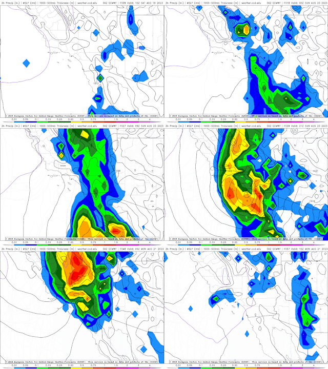
However, the setup is right this time around and we're watching Hilary closely as it moves northward. Baja California is already being affected by heavy rains, and the CONUS is sure to follow over the weekend. Areas of localized precipitation in excess of 14 inches are expected as tropical moisture is forced upward due to elevation. 

Tropical Storm force wind speeds are expected to begin arriving in Southern California by late Sunday morning and will continue throughout the day and into Monday as the storm moves north into elevation. I have also added .gifs to this post of the GFS, NAM, ECMWF, and HRRR for precipitation comparison. 

Hazards Expected

Flooding:

While much rain is needed in the southwestern US, torrential rains of this magnitude will flow downhill faster than they can be absorbed by the dry ground. The rain will surely help the water tables some, but for the most part widespread minor flooding and localized major flooding is possible as water flows downhill. 

Due to the dry nature of the soil, I would expect trees, cacti, shrubs, and other foliage to be uprooted easily once water saturates the top layer of soil. Landslides will be a factor in Baja and So.Cal.

Winds:

Tropical storm force wind speeds are capable of snapping limbs and removing roof tiles and shingles. More extensive damage will be seen further south, but wind damage will still be something to be wary of in southern California. 

Power Outages:

As I am unfamiliar with the west coast and how power transfer works out there (power lines, underground, insulated vs. uninsulated, etc.) I am unable to speak to how electricity may be affected in this area. However, typically tropical systems or organized storms of this magnitude can be associated with loss of power, especially in the event of flooding. Expect some power outages at least temporarily.

As always, stay tuned into your local weather forecasting offices and news stations for the most accurate and up-to-date analysis and information. Stay safe out there in this historic storm!


Thursday, September 29, 2022

Hurricane Ian

Good evening weather enthusiasts! 

Synopsis:

Hurricane Ian tore across Western Cuba, strengthened to a strong category 4 major hurricane before
slamming into Cape Coral, Florida with catastrophic winds and devastating storm surge and flooding up to 16' in places. The storm is now east of Jacksonville, FL over the Atlantic where the tropical engine continues to steam on, having recently downgraded to Tropical Storm status for a short time before strengthening and organizing into a category 1. The storm now has its eye fixed on Charleston, SC and is moving nearly due north at 10 mph. 

While the storm itself isn't as "perfectly formed" as we normally think of a hurricane, the Gulf low expressed in the form of hurricane Ian is interacting with the Canadian High pressure system to create an effect we refer to as Cold Air Damming (CAD) in the winter months. That's part of the reason we've had some beautiful fall weather to start the season, and part of the reason this will be such a rain event. 

The cold pool we've been experiencing is stable air... cold air sinks, warm air rises. Well, now we have a tropical air mass advecting warm, moist air into an already stable atmospheric situation. This is causing a coastal warm frontal effect and "transforming" (if you will) this banded precipitation into a more uniform, stratiform, convective rainfall event. 

Expectations:

Let's talk first and foremost what we can expect from this system. It is moving north northeast at approximately 10 mph on last observation, and has a rain shield extending northeast over 300 miles from the center of circulation. Parts of NC, especially eastern NC out by the coast, are experiencing drought conditions, so the benefit of this rain is that should be alleviated. The unfortunate part of it all is we will likely have localized flooding from storm surge at the coast in addition to rain. Numerous counties are under a Tropical Storm Warning by the National Weather Service, and counties are wisely closing schools and activities for tomorrow to protect their students, staff, and parents. 

Rain Totals

Coast/Coastal Plains/Sandhills: While models are having difficulty getting a read on exactly how much rain can be expected, they're in agreement that there will be heavier precipitation along the coast from New Bern down through Wilmington and into Myrtle Beach, then continuing into the Sandhills until Fayetteville. These areas can expect anywhere from 5-8" of rain. This bullseye in the sandhills could shift west over toward Charlotte depending on the westward movement of Ian.

Piedmont: The Piedmont generally north of I-40 and west of I-95 can expect slightly less by way of precipitation - about 3-5"

Foothills: The foothills will get anywhere from 2-4" depending on the westward push of Ian as it moves north into the Carolinas. The further west, the more rain for the foothills but generally between 2-4" can be expected. 

Elevation: Similarly to the foothills, 2-4" could fall.

Storm Surge

What is storm surge? It's essentially the height the ocean level increases as a result of the storm. A hurricane is a low pressure system, meaning the atmospheric pressure is lower than normal. Water pressure in the ocean, however, stays relatively constant in comparison.

As a result, when this low atmospheric pressure moves over constant ocean pressure, the ocean literally bulges up underneath the storm, creating swells. The extent of those swells due to how strong the wind field is creates a wave fetch, which we try to determine the socioeconomic impact based on shoreline geography, population density, elevation, etc. 

Long story short, the OBX and coastline won't experience nearly the storm surge that Gulf Florida did, however there could still be damage from the 3-5' expected along the coastline. Further South near the strongest winds and center of rotation, storm surge between 5-7' could be experienced. This surge is likely to cause some beach erosion, flood the first floors of buildings not on posts, and move around vehicles, yard furniture, and watercraft. Winds in excess of 70 mph will aid in this shifting of belongings and will likely fell trees and cause minor damage to roofs. 

Hazards:

1. Flooding: make sure you have potable, bottled water in the event of flooding of your home, contamination of city water, or contamination of well water.

2. Wind Damage: Wind can be devastating when paired with water. Tall trees, shallow root structures, and saturated soil here in the deciduous forests could cause plenty of toppled trees, damaging property and cutting power to tens of thousands. Be sure your vehicles are parked in a safe place out from any trees, and please do NOT stay in your car underneath tree limbs.

3. Power Outage: While things won't be as widespread as Florida, our infrastructure is not well-equipped for this type of system and unfortunately the power can go out easily with a felled tree or power pole. Make sure your extra battery packs for your phone are charged, and have a healthy supply of batteries in the event that flashlights become the source of light. 

Remember a couple last things: Turn Around, Don't Drown! If you can't see the roadway, don't try to drive over the road. It only takes a couple inches of water to move your sedan. Secondly, Prepare for the worst, hope for the best. Have your hurricane emergency kit ready to go and in an easily accessible place. 

Thanks for reading, and keep your eyes to the skies! 


Friday, January 14, 2022

Winter Storm Izzy - Major Mess for the East Coast!

Disclaimer *First of all, I apologize for formatting. I was not able to get the text to wrap around the images like I usually can, so things might look a little wonky on the mobile version of this post*...

The "What"

Models were hinting at a major winter storm this weekend around this past Monday or Tuesday, and now that we're within 48 hours models are aligning in their predictive calculations. If you just want totals, types of precipitation, and impacts expected, you can skip to the end. The 4 .gif files that I'm using are the surface and 850 mb model guidance temperature for the GFS and NAM weather models from the 06Z model run through 48-66 hours. I used these to show the differences in each model with respect to temperature at the surface as well as in the mid-atmosphere so that you can see where the model is getting it's guidance from.

The Setup

Synoptically we have the jet stream dipping quite far south, allowing for positive vorticity advection into the deep Southeastern United States, as well as much colder air temperatures plunging southward. The upper-level low is followed closely by the surface low, but the persistent Bermuda High is forcing the surface low to track northward more rapidly than initially modeled.  
The surface low will be moving up through the western Piedmont of NC, which will cause strong warm air advection from the Atlantic to heat the mid-atmosphere to temps above freezing for central NC, however the surface cold pool from the
 last two days of cold air damming from the
 Canadian High and northerly winds has locked in
 sub-freezing surface temperatures for the duration 
of this event until about 21Z Sunday or 00Z Monday (5-9pm Sunday night EST).

The region in which you reside will have a substantial impact on the type of weather you'll experience from this winter storm, named Izzy by The Weather Channel. Were the surface low tracking closer to the coast, this would be another winter storm like that of January 2000 for central NC (22" of snow in Raleigh for those of you who were here at the time). If it were tracking 
more over Fayetteville and up through VA Beach, we would have more of the '04 or '06 ice storm scenario. This time around, the low is tracking northward near Durham, and because of that we're getting a warm nose of air from the Atlantic in the mid-atmosphere (around 850 mb -750 mb, or roughly 1.5km - 3 km, which will quench all snow chances 
throughout the early afternoon to evening hours on Sunday. 

Types of Precipitation by Region:

Mountains

If you want to see snow, the mountains are where you'll 
want to go! Areas west of Pilot Mountain and north of Charlotte will be experiencing an all-snow event through even Monday
 afternoon and could see some pretty nice snow totals with some areas like Boone even topping 1 foot!

Foothills

Places like Hickory, Statesville, and especially further north like Mount Airy and Pilot Mountain will experience mostly snow through the event and due to surface temperatures should have some nice accumulation of up to 8-9 inches, especially areas further north which will benefit from additional accumulation on Monday morning as the low continues to track north. 

Western Piedmont

Getting into Winston Salem and down to Charlotte will experience still snow but less than foothills, however due to that pesky warm nose in the mid-atmosphere the temperature will rise above freezing by mid-afternoon on Sunday which will cause falling precipitation aloft to melt prior to coming into the surface air. The surface air, however, will still be below freezing and thus liquid precipitation will freeze on contact. This is freezing rain. After a few inches of snow (4-6" for this area), precipitation will transition to freezing rain before making a transition back to snow by dinner time for a short while before the precipitation ceases to fall. 

Central Piedmont into Sandhills

This is where things get really messy. Precipitation will begin as early as 4 am Sunday morning in the Sandhills but hold off until around 10-11:00 am as far north as Henderson. The reason behind this is because the cold air settling in on Saturday night is not only cold, but also very dry. Part of the cooling will come occur from a process known as "evaporative cooling", which is the short and sweet describing the process by which liquid moisture evaporates into dry air as it falls, working to saturate the air with respect to water vapor, absorbing heat from the atmosphere to do so. 

I'm expecting precipitation to start as snow prior to lunch in this area, transitioning quickly to sleet then freezing rain before early afternoon. 

Afternoon hours will experience a surface temperature rising above freezing, which will cause liquid rain to fall at the surface and work to reduce accumulations of all types of wintry precipitation. 

Getting into dinner time the temperature will drop back below freezing at the surface, and precipitation will make a shift back to freezing rain before ending around mid-evening on Sunday. 

Coastal Plains

The Coastal Plains will experience mostly liquid rain for the duration of the event, with the heaviest rain occurring mid-afternoon Sunday into dinner time (timing from south to north) as the low tracks northward. 

Types/Accumulations Summary:

Mountains:

Snow: Early Sunday morning - Sunday night: new accumulation 12-15"

Foothills:

Snow: Early Sunday morning - Sunday afternoon: new accumulation 6-8"
Sleet: Sunday afternoon - Sunday evening: new accumulation 1-2"

Western Piedmont

Snow: Early Sunday morning - Sunday afternoon: new accumulation 3-4"
Sleet: Sunday afternoon - dinnertime Sunday: new accumulation 1-2"
Freezing Rain: dinnertime Sunday through Sunday night: new accumulation 0.25-0.3" in spots (primarily eastern Charlotte suburbs/Goose Creek area through Wadesboro looking east and up through Asheboro looking north)

Central Piedmont into Sandhills

Snow: Mid Sunday morning: new accumulation 1-2" (higher totals expected closer to VA border)
Sleet: Late Sunday morning: new accumulation 0.5-1" (higher totals expected closer to VA border)
Freezing Rain: Late Sunday morning - early Sunday afternoon: 0.1-0.25" (more FZRA south into sandhills - Sanford, Lillington, Pinehurst, Fort Brag, and Rockingham and less FZRA north into the Triangle)
Liquid Rain: Sunday afternoon - Sunday evening: new accumulation 0.50-0.75"

*Liquid rain will transition back to freezing rain after dinner into the mid evening on Sunday.

Coastal Plains 

Liquid Rain: Sunday: new accumulation 2.0-2.5"

Impacts:

The major impacts will be to travel and power outages. 

Power Outages:

Since the winds will be picking up throughout the day Sunday and shifting from a northerly wind pattern to more of a westerly/southwesterly pattern and the ground will be wet, I expect downed branches, trees, and power lines. Make sure to have plenty of candles, backup batteries, and flashlights prepared and that you have the blankets you will need washed, because it will get cold on Sunday night and Monday night. 

Travel Impacts:

The roads will be treacherous on Sunday into Monday. Surface temperatures will drop below freezing on Sunday night and again on Monday night. I highly discourage Sunday and Monday travel, especially west of I-95. Tuesday we will likely experience a slick commute west of I-95, and things will likely be closed down between US-1 and I-40 due to ice accumulation on Sunday. 

Stay tuned to your local news stations for updates on the pattern as it may shift slightly in the next 36-48 hours, but this is what we're looking at for now. Be safe and keep your eyes to the skies!

*graphics credits to College of DuPage (weather.cod.edu), NWS, and NOAA for the .gif files and the 5 things to know*

Thursday, February 20, 2020

Jack Frost's Late-Season Appearance!

By now the new is out that much of NC and part of VA will be seeing some unusual white flaky stuff falling from the sky. No, that's not your morning portion of Frosted Flakes... it's SNOW!

The Setup:

High pressure is established off the coast of New England and a low pressure system is pushing past the Carolinas in proximity to the coast. This gives us northeasterly winds and colder air and sustained moisture. As the low tracks out to sea, winds will shove moisture inland above a cool pool of air banked against the mountains which will cause mixed-phase precipitation to fall. While temperatures are not yet freezing at the surface, as frozen precipitation falls and makes contact with the ground, the ground heat flux will act to melt the precipitation, thereby cooling the ground. Continuing precipitation will, after a couple hours, begin sticking to the ground which at that time will have dropped to freezing.

Where:

At this point it is quite clear that the Mountains, and East of Charlotte to North of Fayetteville will all see some effect of this winter storm. While models have yet to agree on the exact bullseye for heaviest precipitation, there is general consensus that the further North and East you go toward Virginia Beach, generally the more accumulation expected, and the further South and West toward Charlotte and toward the SC border likely only rain to Trace (<0.01") is expected).

When:

The precipitation will begin as rain for the majority of the region, transitioning to snow for the central Piedmont to the coast as the day wears on. It will begin primarily as snow the further north you are. Precipitation will begin falling in the Charlotte Metro around 9-10, progressing to the east north east. By lunch time most of NC will be experiencing precipitation, and by 4:00 p.m. northern and northeastern NC will have transitioned to snow. Precipitation will have stopped falling by the morning commute on Friday, however totals will have stacked up by then.

How Much (winter, that is):

Charlotte: trace to 0.5"
Fayetteville: ~0.5" to 1"
Greensboro: ~0.5" to 1"
Durham: 0.5" to 1.5"
Sanford: ~0.5" to 1"
Raleigh: 1" to 2"
Henderson: 2" to 3"
Wilson: 2" to 3"
Goldsboro: 2" to 3" 
Kinston: 2" to 3"
Greenville: <5"
Rocky Mount: <5"
Roanoke Rapids: 2" to 3"
South Hill, VA: 1" to 2"

These are rough estimates based model guidance. It's not fact, and should be compared to other sources. With storms such as these which have little confidence in terms of amount and location, I like to air on the side of caution when reporting forecast amounts. This is not to say that these totals above will not have an impact for the Friday commute. 

How long will it last?

The temperature this weekend will be rising back into the 50s with sunny skies for most of the region behind this system, meaning things will melt away fairly quickly. Thursday night into Friday morning is the main concern with respect to travel.

Please be safe! Have your weather radio and flashlight handy in case of power outage! Stay off the road if you do not have to leave the house! Last but not least, enjoy the first real snow of this winter!


Friday, January 11, 2019

First bout with Winter 2019

It looks like we are going to have another taste of Jack Frost’s (or Elsa’s) winter weather making potential, although it won’t be quite as nice as the last experience. I am writing this from my phone as my computer is packed and ready to go back to Iowa with us tomorrow (my wife Cassie and I are driving, so that’ll be fun haha!) so I’ll get right into it:

Things may start as early as Saturday afternoon for NW and NC North Carolina and will likely be light snow. As the day progresses, wintry precipitation will build in from the SW portions of the state likely in the form of sleet or a mix, with not much snow accumulation. This mix will continue its path into central and north central NC by late Sunday morning. Saturday overnight the p-type (precipitation type) will likely make a transition back to snow and the foothills and NW piedmont should see some accumulation up to a few inches. Unfortunately it looks as though even Asheville will only see sleet and freezing rain from this event, so only places such as Mt. Airy, Boone, Grandfather Mountain, and Winston Salem will see snow accumulation.

Freezing rain looks to be the main hazard with this storm. While dynamics within the weather models are good, it’s hard to predict the future. However, right now the models are showing between 0.25 and 0.4” of freezing rain across most of the western half of the state (cut by US-64). The Sandhills will experience mostly rain if any precipitation at all, and closer to the coast south and east will be drier with this storm. New Bern, Elizabethton, Kitty Hawk, and up into Virginia Beach can expect the heaviest precipitation, the vast majority of which will be rain.


Saturday, December 8, 2018

Iiiii'm Dreamin'... of a whiiiite, Christmaaaas

Santa Claus is on his way and winter weather is here to stay (at least for a little while)! Colder conditions have been setting up for a few days now in the Carolinas with high pressure parked over the New England states and the Gulf Low working together to bank up a nice pool of cold air against the Appalachian mountains. Now the trough is making it's way across the U.S. and Gulf moisture is being fed up the coast.


Models are in agreement on one thing: there will be precipitation in the Carolinas and Southern Virginia and it will be heavier toward the mountains.


Region

On the left I have pasted screen captures taken from the College of DuPage "Next Generation Weather Lab" where one can observe the model output for the American weather models. These images are every 6 hours starting 7:00 p.m. Saturday through 1:00 a.m. Monday (top to bottom).

*This is raw model output for precipitation type at each of these times and should not be taken as a numerical forecast*

I wanted to include these images to help viewers see some of what forecasters are looking at when they make their forecasts. This is ONE set of images from ONE weather model for ONE atmospheric parameter, and is by no means the entire picture.

East and South of I-95


For the Sandhills and Coast, this will likely start as rain Saturday afternoon further south and continue as rain through the event, creeping northward overnight Saturday into Sunday and throughout. There is a chance that temperatures will cool enough to see some mix into Sunday afternoon/evening, but I expect the event to be all rain for this region. Amount of precip will decrease northward east of I-95 and the coastal area can expect between 1.25" (Northernmost Sandhills/coast) and 2" (Southern most near Kure Beach and the SC border).
West of I-85, SC/NC Border

The foothills and mountains will experience the most accumulation of snowfall throughout the event. The latest model runs are suggesting on the order of 12"+ for this region. Precipitation will begin falling in the western-most reaches of the state as early a few hours from now, and will be a mix of snow and rain. As the weather system progresses eastward, snowfall will intensify northward and rainfall will intensify eastward until around dinner time when a mix will start to be experienced west and north of Charlotte and west and south of Winston Salem. Overnight as the temperature continues to cool an precipitation falls into the Cold Air Damming Wedge banked up against the mountains, the transition will be made to snow quite rapidly across the state from the mountains all the way to I-95. The Sandhills and NC/SC border west of State highway 1 will likely experience a mix, and east of State Highway 1 will likely experience rain through this time.

This will make the transition over to largely sleet/mix by Sunday late morning/early afternoon, and further transition to freezing rain into the evening on Sunday.

Between I-85, I-95

Central NC will be a mess for sure, but there will still be plenty of that magic weather from the North Pole for a good portion of Sunday. Saturday will be a primarily rain/mix event for the Piedmont, and the Triangle should begin seeing snow fall steadily around midnight-1:00 a.m.. This will continue for areas as far south as Sampson and Moore counties until breakfast time Sunday when the transition to mix will follow a northward time progression at about (one county)/(two hours). By the early afternoon Wake County and areas along and south of I-40 will be experiencing a mix if not freezing rain, and the transition to liquid will close in a horse shoe around Winston Salem late Sunday night before moving out.

Hazards

1. Roads will be very hazardous from west to east starting as early as a few hours from now. Be mindful of the conditions and please stay off the road if at all possible. Leave the paths clear for emergency crews and power companies to make their way to their destinations.

2. Power Outages could become a very real situation in Central NC as well as places further west as up to 0.2" of freezing rain is expected to fall in areas across NC. This much freezing rain plus a moderate gust of wind is more than enough to take lines down.... another reason to stay off the road if you can.

3. Cold Temperatures are expected to continue for a couple days after the event with lows dropping into the low 20's by Tuesday night. Be mindful of how much of your body is exposed to the elements must you venture outside.

Expected Accumulations

Mountains: The mountains can expect the greatest snow accumulation of up to 12"+ in some areas
Foothills: Anywhere from 4-8" of snow followed by 1-2" of snow/sleet mix
Northern Piedmont: Anywhere from 4-8" of snow followed by 1-2" of snow/sleet mix; 0.05" frz rain
Central Piedmont: 2-3" snow followed by 2-3" snow/sleet; 0.1" frz rain
Sandhills: 1-2" mix
Coast: 1.5-2" rain, occasional mix further north

These conditions are expected to pan out slightly differently than what is listed above, however I wanted to put together thoughts of forecasters and model information to try to keep everyone as informed as possible for their location. Please tune into your local news/radio stations for updates on the event, and if you can spare a second or two, don't be afraid to share pictures and your location for documentation of the event!

Coming into the Christmas season, I hope everyone can be filled with the Joy of the Spirit of Jesus as we get closer to the celebration of His coming. Merry Christmas everyone!

Thursday, September 13, 2018

Florence Update

As expected, the path of Florence has changed, however the threats mentioned before will be no less impactful. I will get right into it:

Where


The latest path forecast based largely on model guidance has Florence making landfall in Wilmington as a Category 2 hurricane. Shortly after landfall and after many hours of actually interacting with the land (as this storm is HUGE), wind speeds will slow to category 2 strength (max sustained up to 110 mph.

The likely path of the storm will be to take a turn to the southwest shortly after making landfall as it gets caught in the northeasterly (from the North East) flow from the synoptic ridge building into the northeastern United States. This, in addition to friction, will also cause the storm to slow down in it's forward propagation, which will allow for large precipitation totals along the coast of NC and into central NC and central SC.

The storm, at this point, looks like it will continue its southwestward trend through SC, and once the ridge (mentioned above) clears out to the northeast, the storm will get caught in the lifting trough and rapidly move northward. Remember, this storm is very, very big from an areal extent.... over 400 miles wide. Rain will be falling over a huge portion of the United States for a number of days.

When

Right now the National Hurricane Center has Florence making landfall early morning Friday. This time of landfall (or nearest proximity) to Wilmington has been slowly moving later in the week as the storm approaches and we get a better idea of how fast and to where it is moving. Part of the reason so much has been closed and will be closed for a few days ahead of forecasted landfall is to give residents a chance to get out, deal with traffic, and get to their desired safe spot with enough time prior to the storms initial impacts. The storm will continue to wash out the Carolinas, GA, and southern VA through the weekend and into early next week.

At that point, the first phase of Florence will have passed, but the potential worst for many lower-lying communities along the major rivers traversing the NC/SC border (images to the left). As 10-20" of rain falls throughout the duration of Florence, that water eventually has to flow back downhill. This means the flooding experienced by North and South Carolinians during and after Matthew in October 2016 will be felt again, and this time with more of a negative impact because of the amount of water. It will take a couple of weeks for all the water in western NC to make its way to the SC coast, flowing through major cities like Charlotte, NC, Columbia, SC, Florence, SC, and eventually out to the coast.

Florence from GOES-East GEOCOLOR
13 Sep 2018 07:07 UTC
On the left I have provided the latest flash flooding potential map from the National Oceanic and Atmospheric Administration. Keep in mind, flash flooding refers to floods relating to localized heavy rainfall, not the traversing downhill which will result days and weeks after that localized heavy rainfall occurs. Flood warnings will be issued as necessary by the National Weather Service, as our forecasters have been and will continue to spend major overtime hours pouring over model guidance and the latest trends to keep us as informed as they can. Overlapping 12-hr shifts take a toll after a while and they have been doing amazing work keeping us informed.

What/How Much

Precipitation:
The heaviest precipitation will fall in Wilmington, NC and surrounding communities. In these areas, I'm expecting upwards of 30"+ of rain. SE NC and NE SC will receive between 10-20" of rain. Central SC-Northwestern NC, around to Central NC and out to the coast and that band will likely receive 3-5" of precipitation. Basically the rest of NC, South Central SC, NE GA, and SE/SCentral VA, and Eastern TN will likely receive 1-5" of rain.


Wind:
One thing about this storm that has me awestruck is the sheer size of the storm... While it is losing some strength as dry air is getting entrained and thus hindering the storms ability to restrengthen (VERY good in many ways for the coast). The current max sustained winds are 110 mph and those speeds extend about 50-75 miles out from the storm center. Tropical Storm force wind speeds (>45 mph) extend over 200 miles from the storm center to the West, North, and East. Winds will have an impact along the coast and will produce notable storm surge along the coast of primarily NC and southeastern VA.

Storm Surge Storm surge from this system will range from 13-18 feet closest to the center of the storm and in the NE quadrant of the storm. Surge will be highest in SE NC, the southern Outer Banks, and the Pamlico Sound/Neuse River. Early storm surge estimates have surge equivalent to 9' AGL (above ground level, as opposed to above sea level) reaching as far as Greenville, NC along the Neuse River, which is normally very shallow anyway. Wave heights will aid storm surge potential and fortunately a full moon will not. Another thing to watch out for is the storm making landfall at high tide. That adds 3-4' of water as a foundation for the waves to build off of and move inland. The longer the storm stalls before moving inland to SC, the worse the flooding from storm surge will become. Rain, as discussed earlier, will continue through the event as the storm progresses east/southeastwards.


Hazards:

The hazards for the storm remain largely the same from the last post:

1. Flash Flooding - The flash portion of this will result mostly at the coast of North Carolina and Virginia
2. Wind - Winds are strong enough and the water tables saturated enough that it won't be an outlandish event to see a tree or tall structure topple over.
3. Power Outages - Once this storm comes ashore, winds will batter trees and structures, and trees could topple over.
4. Potential Isolated Tornadoes. As the rain band moves ashore, the friction from the land causes a change in the force balance diagram and will become mini areas of maximum vorticity, or atmospheric rotation.
5. Flooding down the road: If this storm will be analogous or worse than Matthew, It will take weeks to see how much water is actually going to flow down hill and over road surface. 

Recap

For now just stay hunkered down. A few matches and candles can't hurt anymore. Stay tuned to your local weather station for the latest information. Florence is a Category 2 hurricane and will likely stay that way through its landfall and path over land. There will be lots of rain, some wind, and very high storm surge.

Be safe, and be smart out there during this storm!