More Tropical Activity in the Near-Equatorial Atlantic! This is going to be a very short and rather uninformative post because I do not have time to write it, but I needed to update you all on this new tropical activity.
Currently, Tropical Storm Bertha is due east of the Island of Barbados and is tracking West-Northwest.
If you have family in the Caribbean Islands, make sure they are notified of the potential for Tropical-Storm-Force winds and rain.
Friday, August 1, 2014
Thursday, July 3, 2014
Coastal Forecast *Hurricane* Arthur
Okay ladies and gentlemen this is it! The forecast you've all been waiting for! I currently have friends and family in Oak Island, Wilmington/Wrightsville Beach, Atlantic Beach, and Ocracoke Island so I will make a forecast for each location estimating rainfall, storm surge, wind speed, estimated time of arrival, and duration of Hurricane Arthur for each location. See the beaches in order of Landfall below.
Holden Beach/Ocean Isle/Sunset Beach/Oak Island
The Southeastern Beaches of NC will experience the force of Hurricane Arthur before the rest of the state. This area is currently under a Tropical Storm Warning, since Hurricane Arthur will not actually be making landfall, the eye wall (area with strongest wind speed) will not be hitting this portion of NC. People living in this area can expect to see sustained winds of around 50 kts (~58 mph) with gusts reaching the triple digits. Rain will vary depending on whether the hurricane meets up with the cold front currently moving across our state or not but if so, beach-goers can expect to see around 2-3 inches of rain. The potential storm surge in this area could be around 3 feet above ground, but since the elevation of the region is around 20 feet above sea level, that surge could be diminished. Nonetheless, If you have anything on the ground floor in your garages, it would be good to move those into the house where they will stay dry. The center of the storm is currently about 6.5 degrees lat south and about 1 degree west long moving north-northeastward at about 10 mph. This means that the highest storm surge will be experienced at around 5:00 p.m. and the strongest wind and rain will be experienced around 11:00 p.m.. The storm will likely last around 20 hours (including what has already been experienced), so the fourth of July plans shouldn't be postponed for this area.
It is safe to ride out the storm in this area.
Wrightsville Beach
Both the Holden Beach area and the Wrightsville Beach area are already experiencing some of Arthur. Wrightsville Beach should expect wind speeds around 60-65 kts (69-74 mph) with gusts coming later this evening near 80 mph. Those living in the Wrightsville Beach/Wilmington area can expect around 3-4 inches of rain in the next 36 hours. Storm Surge for Wrightsville Beach/Masonboro Island is predicted at around 4-5 feet, and the Wilmington area surrounding the Cape Fear River should see around 3 feet of storm surge. It would be a good idea to move items into higher areas. The highest storm surge of Arthur should be around 7:00-7:40 p.m. and the highest winds will likely occur around and after midnignt. Arthur should move out of the area by around breakfast time.
It is probably safe to ride out the storm on Wightsville Beach, but I would not recommend it. If you live on the Wilmington mainland, you should be okay.
Atlantic Beach
Atlantic Beach will be the first point of landfall for the eye of Hurricane Arthur. Wind speeds of up to 90 mph can be expected in this region on the back side of the eye wall and storm surge will be around 6-7 feet. The highest surge and strongest winds will both be experienced around 3:00-4:00 tomorrow morning (July 4th) as that is when the eye is going to make landfall on the island. The storm should last around 30-36 hours. The Fourth of July festivities have been postponed until 5:00 p.m. on Saturday, July 5th.
I would highly recommend evacuating this area, as the combination of storm surge and wind speed could provide for devastating effects.
Ocracoke Island
Ocracoke Island shouldn't experience the same force as Atlantic Beach. Though the eye will pass over Ocracoke Island, the surge will not be quite as bad. Surge will probably still be between 3 and 6 feet in some places, but generally the surge will be lower than 3-4 feet. The sustained wind speeds and gusts will be about the same as Atlantic Beach with sustained winds between 75-80 mph and gusts up to 90, and Ocracoke can expect between 3-4 inches of rain. These will be experienced just an hour or two after Atlantic Beach and can be expected between 4:00-6:00 tomorrow morning. The storm will last until the early afternoon. The Fourth of July festivities have been postponed until 5:00 p.m. on Saturday, July 5th.
It should be safe to ride out the storm but I am not promising that your house will not get very wet.
Extra Important Information
Be careful of Tornadoes! Many times the damage of hurricanes comes from tornadoes embedded inside the walls of the hurricane and can be accompanied by hail and heavier rain. Stay tuned to your local weather stations as often and for as long as you can if you decide to ride out the storm!
If you have any questions about storm surge, visit this site and click continue. This storm surge map is "experimental" and is being used to estimate surge for locations in the path of the hurricane based on numerous mathematical formulas and derivations.
http://www.nhc.noaa.gov/refresh/graphics_at1+shtml/154057.shtml?inundation#contents
Holden Beach/Ocean Isle/Sunset Beach/Oak Island
The Southeastern Beaches of NC will experience the force of Hurricane Arthur before the rest of the state. This area is currently under a Tropical Storm Warning, since Hurricane Arthur will not actually be making landfall, the eye wall (area with strongest wind speed) will not be hitting this portion of NC. People living in this area can expect to see sustained winds of around 50 kts (~58 mph) with gusts reaching the triple digits. Rain will vary depending on whether the hurricane meets up with the cold front currently moving across our state or not but if so, beach-goers can expect to see around 2-3 inches of rain. The potential storm surge in this area could be around 3 feet above ground, but since the elevation of the region is around 20 feet above sea level, that surge could be diminished. Nonetheless, If you have anything on the ground floor in your garages, it would be good to move those into the house where they will stay dry. The center of the storm is currently about 6.5 degrees lat south and about 1 degree west long moving north-northeastward at about 10 mph. This means that the highest storm surge will be experienced at around 5:00 p.m. and the strongest wind and rain will be experienced around 11:00 p.m.. The storm will likely last around 20 hours (including what has already been experienced), so the fourth of July plans shouldn't be postponed for this area.It is safe to ride out the storm in this area.
Wrightsville Beach
It is probably safe to ride out the storm on Wightsville Beach, but I would not recommend it. If you live on the Wilmington mainland, you should be okay.
Atlantic Beach
Atlantic Beach will be the first point of landfall for the eye of Hurricane Arthur. Wind speeds of up to 90 mph can be expected in this region on the back side of the eye wall and storm surge will be around 6-7 feet. The highest surge and strongest winds will both be experienced around 3:00-4:00 tomorrow morning (July 4th) as that is when the eye is going to make landfall on the island. The storm should last around 30-36 hours. The Fourth of July festivities have been postponed until 5:00 p.m. on Saturday, July 5th.
I would highly recommend evacuating this area, as the combination of storm surge and wind speed could provide for devastating effects.
Ocracoke Island
It should be safe to ride out the storm but I am not promising that your house will not get very wet.
Extra Important Information
Be careful of Tornadoes! Many times the damage of hurricanes comes from tornadoes embedded inside the walls of the hurricane and can be accompanied by hail and heavier rain. Stay tuned to your local weather stations as often and for as long as you can if you decide to ride out the storm!
If you have any questions about storm surge, visit this site and click continue. This storm surge map is "experimental" and is being used to estimate surge for locations in the path of the hurricane based on numerous mathematical formulas and derivations.
http://www.nhc.noaa.gov/refresh/graphics_at1+shtml/154057.shtml?inundation#contents
Wednesday, July 2, 2014
Tropical Storm Arthur
Does anyone remember the show from the 90's? Yeah, I remember growing up with Arthur as one of the cartoons I watched on a regular basis. This Arthur however is far from a cartoon.
The first named storm of the 2014 Atlantic Hurricane Season is Tropical Storm Arthur. Currently packing sustained winds of 35-45 knots with gusts reaching 55 knots at times, Arthur is located 3 degrees east of the Florida/Georgia border and is currently moving N. It is expected to turn more toward the NE and hit the Outer Banks of NC as the Primary Landfall point before continuing up the East Coast. It is possible that this storm could become a Cat 1 Hurricane before making landfall. Regardless of the meteorological categorization, we will experience hurricane force winds in the outer banks should Arthur continue on it's NNEward path. I am considering driving out Thursday night after work so that I can grab some pictures and videos from the beach to post! And because it would be fun haha!
We also have a Tropical Storm in the Eastern Pacific, Tropical Storm Douglas, which will continue NWward into the mid-Pacific Ocean.
So, why was Tropical Arthur able to form? Don't Hurricanes form off the coast of Africa and move in a semicircle path, or form in the gulf and die over the US? Not exactly. There are six factors which contribute to hurricane formation:
1. SST (Sea Surface Temperature) needs to be greater than 80 degrees Fahrenheit for optimal Hurricane formation
2. Easterly Wave or perturbation needs to occur to begin rotation off the coast of Africa
3. Low Wind Shear
4. A convectively unstable atmosphere
5. Sufficient low-level moisture for entrainment or feeding the hurricane
6. Coriolis greater than 5 degrees from the equator. Coriolis is one of the main atmospheric forces when balancing atmospheric rotation and movement of air, and gets stronger with increased speed, rotation, or distance from the equator. The two other forces balanced by Coriolis Force are Pressure Gradient Force and Friction.
When hurricanes form in the Western Atlantic or Gulf of Mexico, the Easterly Wave is not the cause of hurricanes. Typically it's as a result of the Continental Low being trapped between the Bermuda High and the Canadian High pressure systems. This is exactly what happened with Tropical Storm Arthur. The rotation of the Continental Low just off the coast of Florida was accelerated by the Canadian High to the Northeast, and the Bermuda High to the Southwest. The rotation acceleration and stationary location over the warm mid-tropical Atlantic waters allowed for a rapid intensification of the Low. Above is the National Forecast Map for June 30, and it is clear that the High Pressure systems are accelerating the Low. The Low rotates counterclockwise, and each of those four Highs are rotating clockwise. That Low meteorologically is trying to get back to it's normal position over the Southeastern United States, but the four High Centers kept it from moving back and accelerated the rotation. Now, the Tropical Storm is moving up the East Coast and following the Gulf Stream and trade winds and will continue until it dies out.
More accurate information will come tomorrow as the track is easier to forecast 24 hours out. I will have more of a forecast post instead of an informational post tomorrow. If you live on the coast, shopping wouldn't be a bad idea! Power shouldn't go out but with weather, anything can happen.
The first named storm of the 2014 Atlantic Hurricane Season is Tropical Storm Arthur. Currently packing sustained winds of 35-45 knots with gusts reaching 55 knots at times, Arthur is located 3 degrees east of the Florida/Georgia border and is currently moving N. It is expected to turn more toward the NE and hit the Outer Banks of NC as the Primary Landfall point before continuing up the East Coast. It is possible that this storm could become a Cat 1 Hurricane before making landfall. Regardless of the meteorological categorization, we will experience hurricane force winds in the outer banks should Arthur continue on it's NNEward path. I am considering driving out Thursday night after work so that I can grab some pictures and videos from the beach to post! And because it would be fun haha!We also have a Tropical Storm in the Eastern Pacific, Tropical Storm Douglas, which will continue NWward into the mid-Pacific Ocean.
So, why was Tropical Arthur able to form? Don't Hurricanes form off the coast of Africa and move in a semicircle path, or form in the gulf and die over the US? Not exactly. There are six factors which contribute to hurricane formation:
1. SST (Sea Surface Temperature) needs to be greater than 80 degrees Fahrenheit for optimal Hurricane formation
2. Easterly Wave or perturbation needs to occur to begin rotation off the coast of Africa
3. Low Wind Shear
4. A convectively unstable atmosphere
5. Sufficient low-level moisture for entrainment or feeding the hurricane
6. Coriolis greater than 5 degrees from the equator. Coriolis is one of the main atmospheric forces when balancing atmospheric rotation and movement of air, and gets stronger with increased speed, rotation, or distance from the equator. The two other forces balanced by Coriolis Force are Pressure Gradient Force and Friction.
When hurricanes form in the Western Atlantic or Gulf of Mexico, the Easterly Wave is not the cause of hurricanes. Typically it's as a result of the Continental Low being trapped between the Bermuda High and the Canadian High pressure systems. This is exactly what happened with Tropical Storm Arthur. The rotation of the Continental Low just off the coast of Florida was accelerated by the Canadian High to the Northeast, and the Bermuda High to the Southwest. The rotation acceleration and stationary location over the warm mid-tropical Atlantic waters allowed for a rapid intensification of the Low. Above is the National Forecast Map for June 30, and it is clear that the High Pressure systems are accelerating the Low. The Low rotates counterclockwise, and each of those four Highs are rotating clockwise. That Low meteorologically is trying to get back to it's normal position over the Southeastern United States, but the four High Centers kept it from moving back and accelerated the rotation. Now, the Tropical Storm is moving up the East Coast and following the Gulf Stream and trade winds and will continue until it dies out.More accurate information will come tomorrow as the track is easier to forecast 24 hours out. I will have more of a forecast post instead of an informational post tomorrow. If you live on the coast, shopping wouldn't be a bad idea! Power shouldn't go out but with weather, anything can happen.
Sunday, June 29, 2014
Summer Tropical Activity!
Hello All!! I have great news (Or it could be bad news depending on how you feel about tropical cyclones)! There is a 30-40% chance of tropical cyclone formation in the Mid-Atlantic within 24-48 hours, and a 50-60% chance for cyclone formation for the 90-114 (4-5 day) hour outlook. I will keep you all posted on this as new discoveries about the system are made. Below is the TC Outlook for the Western Atlantic:
Also, the National Hurricane Center is issuing advisories in the Eastern Pacific for Tropical Depression FOUR-E which will likely intensify into a Tropical Storm later today. These are wind and high-seas advisories for small and medium sized watercraft in the area and fishermen and boaters need to be careful of the storm. As you can see, the forecast cone for Tropical Depression FOUR-E shows the storm moving further out into the lower-latitudinal Pacific.
North Carolina
Weather should be beautiful and summer-like yet again in the Triangle and Sandhills. In Raleigh today, the temperature will probably hang around the mid 80s with mostly sunny skies. In the mountain cities, it is likely that rain will persist throughout the day as the Low Pressure Center SE of South Carolina and the High Pressure System NE of Virginia are combining for an influx of warm moist air, which will cause condensation and rain because of the forced lifting by the mountains. The beach should have nice weather, similar to the plains, but could see isolated thunderstorms throughout the afternoon and evening. Wilmington should see high temperatures around 85 with a chance for an isolated thunderstorm.
United States
At this time there are a few storms moving across the Midwest. Storms are showing up on the Doppler in North Dakota, on the TN/AR border, and along Lake Superior. There is also some rain on the leeside of the Appalachians in VA, NC, and SC.
Southern and Eastern Utah along with Western Colorado are under a Red Flag warning as conditions are favorable for the spread of wildfires.
Also, as I am writing this, there is a tornado warning in NW Kansas and the storm is moving SE! If you live between Oakley and Scott City, Kansas take cover and put your severe weather safety plans to good use!
ZCZC MIATWOAT ALL TTAA00 KNHC DDHHMM TROPICAL WEATHER OUTLOOK NWS NATIONAL HURRICANE CENTER MIAMI FL 200 AM EDT SUN JUN 29 2014 For the North Atlantic...Caribbean Sea and the Gulf of Mexico: 1. A broad area of low pressure located about 200 miles east of the coast of Georgia continues to produce disorganized showers and thunderstorms. Environmental conditions are expected to remain conducive for gradual development of this system while it drifts southward offshore of the northeastern and east-central Florida coast during the next few days. An Air Force Reserve Hurricane Hunter aircraft is scheduled to investigate this system this afternoon, if necessary. * Formation chance through 48 hours...medium...40 percent. * Formation chance through 5 days...high...60 percent. Forecaster Pasch
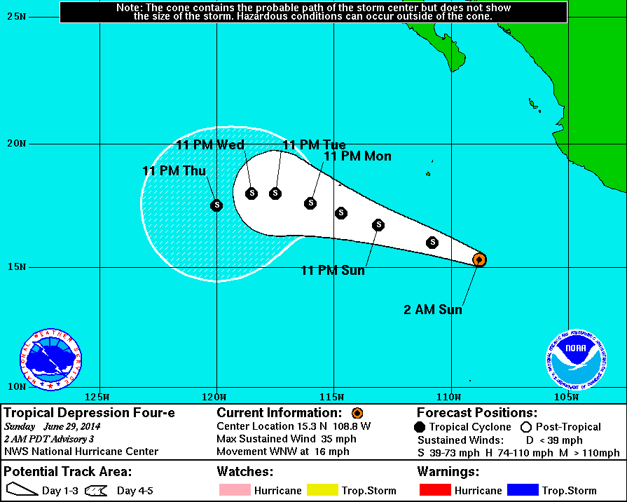
Also, the National Hurricane Center is issuing advisories in the Eastern Pacific for Tropical Depression FOUR-E which will likely intensify into a Tropical Storm later today. These are wind and high-seas advisories for small and medium sized watercraft in the area and fishermen and boaters need to be careful of the storm. As you can see, the forecast cone for Tropical Depression FOUR-E shows the storm moving further out into the lower-latitudinal Pacific.North Carolina
Weather should be beautiful and summer-like yet again in the Triangle and Sandhills. In Raleigh today, the temperature will probably hang around the mid 80s with mostly sunny skies. In the mountain cities, it is likely that rain will persist throughout the day as the Low Pressure Center SE of South Carolina and the High Pressure System NE of Virginia are combining for an influx of warm moist air, which will cause condensation and rain because of the forced lifting by the mountains. The beach should have nice weather, similar to the plains, but could see isolated thunderstorms throughout the afternoon and evening. Wilmington should see high temperatures around 85 with a chance for an isolated thunderstorm.
United States
At this time there are a few storms moving across the Midwest. Storms are showing up on the Doppler in North Dakota, on the TN/AR border, and along Lake Superior. There is also some rain on the leeside of the Appalachians in VA, NC, and SC.
Southern and Eastern Utah along with Western Colorado are under a Red Flag warning as conditions are favorable for the spread of wildfires.
Also, as I am writing this, there is a tornado warning in NW Kansas and the storm is moving SE! If you live between Oakley and Scott City, Kansas take cover and put your severe weather safety plans to good use!
Thursday, June 19, 2014
Severe Weather Statement
Well, I was going to post this on Tuesday but work hasn't been more crazy. Below is the video of the special weather statement for the Nebraska twin twisters on June 16th. Both of these tornadoes clocked wind speeds of nearly 200 mph making them both EF4's on the Enhanced Fujita Scale. The storm chasers in this video who are down the road at the start of the video are Reed Timmer and his team. They were dropping ground probes in front of the tornado. https://www.youtube.com/watch?v=9GOALuziIv4
As the temperatures rise, the potential for more severe storms increases. Higher surface temperatures likely means greater instability which permits violent turning in the atmosphere producing more and more of these supercell thunderstorms. Below is the forecast map and radar for the United States right now.
Fortunately we don't see more colors on both of these maps at the current time. I am glad that there are no Red Flag Warnings down in the Southwestern United States (which would appear as hot pink on the alert map and splotchy blue on the radar). There is a good-sized system moving across into Illinois and Indiana which has a history of flooding and potential for a few tornadoes as well. Also, be aware of the other storm moving across Oklahoma right now. As temperatures rise, we could see some potentially severe weather produced from that.

Speaking of temperatures rising, the high in Raleigh yesterday was 97 degrees with a heat index of 101. This is an interesting fact because the hottest day of Raleigh's summer last year only reached 96 and that was on July 16th. We are in for a beater here in NC. Make sure you are all drinking plenty of water as the temperatures rise in order to prevent heat exhaustion or heat stroke.
At this time there are no tropical cyclones in the Atlantic or Pacific Oceans.
I hope you all are having a great week! Congratulations to the USA Men's Soccer Team as they defeated Ghana 2-1 last Monday night! I look forward to watching them take on Portugal this Sunday, on my 21st birthday, in hopes to make it out of the group of death and into the elimination round!
As the temperatures rise, the potential for more severe storms increases. Higher surface temperatures likely means greater instability which permits violent turning in the atmosphere producing more and more of these supercell thunderstorms. Below is the forecast map and radar for the United States right now.
Fortunately we don't see more colors on both of these maps at the current time. I am glad that there are no Red Flag Warnings down in the Southwestern United States (which would appear as hot pink on the alert map and splotchy blue on the radar). There is a good-sized system moving across into Illinois and Indiana which has a history of flooding and potential for a few tornadoes as well. Also, be aware of the other storm moving across Oklahoma right now. As temperatures rise, we could see some potentially severe weather produced from that.
Speaking of temperatures rising, the high in Raleigh yesterday was 97 degrees with a heat index of 101. This is an interesting fact because the hottest day of Raleigh's summer last year only reached 96 and that was on July 16th. We are in for a beater here in NC. Make sure you are all drinking plenty of water as the temperatures rise in order to prevent heat exhaustion or heat stroke.
At this time there are no tropical cyclones in the Atlantic or Pacific Oceans.
I hope you all are having a great week! Congratulations to the USA Men's Soccer Team as they defeated Ghana 2-1 last Monday night! I look forward to watching them take on Portugal this Sunday, on my 21st birthday, in hopes to make it out of the group of death and into the elimination round!
Monday, June 16, 2014
Birthday Month!
Well, today is June 16th. Happy belated Father's Day dad!! Disappointed that I couldn't spend it with you but I know that you are having a fantastic trip! After a beautiful Father's Day here in North Carolina, we had a gorgeous start to the week! Today happens to be my younger brother's 19th birthday. HAPPY BIRTHDAY DAVID! He is actually not in the states right now, as he is on a mission's trip to Peru! This post is especially for him as I needed to post on his birthday. Where has the time gone?? I remember the days of raking out in the front yard, or playing street hockey or basketball in the cul-de-sac, or playing capture the flag in our neighbors yards after the sun set in the winter. Now, we share different memories, like traveling to Spain with the NC State Power Sound of the South Marching Band, or throwing the Frisbee in Duke Gardens. My how times have and memories have changed, yet I love how we can still enjoy our time with each other.
My brother is on a bus right now to Chincheros, Peru up in the mountains. Currently, the temperature is 43 F with temperatures expected to drop to 37 with clear skies. Tomorrow the high is forecasted to reach the mid 60s with partly sunny skies and a chance for showers. The forecast is basically exactly the same for Wednesday.
Here in Raleigh there is an Air Quality Statement as Ozone levels are dangerously high at the surface level so be careful if you start feeling off while you're outside. Below is the current outlook:
My brother is on a bus right now to Chincheros, Peru up in the mountains. Currently, the temperature is 43 F with temperatures expected to drop to 37 with clear skies. Tomorrow the high is forecasted to reach the mid 60s with partly sunny skies and a chance for showers. The forecast is basically exactly the same for Wednesday.
Here in Raleigh there is an Air Quality Statement as Ozone levels are dangerously high at the surface level so be careful if you start feeling off while you're outside. Below is the current outlook:
NCZ007>009-024>026-040>042-180100- PERSON-GRANVILLE-VANCE-ORANGE-DURHAM-FRANKLIN-CHATHAM-WAKE-JOHNSTON- INCLUDING THE CITIES OF...ROXBORO...OXFORD...BUTNER...CREEDMOOR... HENDERSON...CHAPEL HILL...CARRBORO...DURHAM...LOUISBURG... FRANKLINTON...SILER CITY...PITTSBORO...RALEIGH...CARY...SMITHFIELD... CLAYTON...SELMA...BENSON 432 PM EDT MON JUN 16 2014 ...AIR QUALITY ALERT IN EFFECT FROM 6 AM TO 9 PM EDT TUESDAY... THE NORTH CAROLINA DEPARTMENT OF ENVIRONMENTAL AND NATURAL RESOURCES HAS ISSUED AN AIR QUALITY ACTION DAY FOR THE TRIANGLE...IN EFFECT FROM 6 AM TO 9 PM EDT TUESDAY. A CODE ORANGE AIR QUALITY ALERT FOR OZONE HAS BEEN ISSUED. GROUND LEVEL OZONE CONCENTRATIONS WITHIN THE REGION MAY APPROACH OR EXCEED UNHEALTHY STANDARDS. MEMBERS OF SENSITIVE GROUPS MAY EXPERIENCE HEALTH EFFECTS...THOUGH THE GENERAL PUBLIC IS UNLIKELY TO BE AFFECTED. FOR ADDITIONAL INFORMATION...PLEASE VISIT THE NORTH CAROLINA DIVISION OF AIR QUALITY WEB SITE AT HTTP://DAQ.STATE.NC.US/AIRAWARE/FORECAST/ $$
NCZ057-069>072-082-180145- ROWAN-LINCOLN-GASTON-MECKLENBURG-CABARRUS-UNION NC- INCLUDING THE CITIES OF...SALISBURY...LINCOLNTON...GASTONIA... CHARLOTTE...CONCORD...MONROE 944 PM EDT MON JUN 16 2014 ...AIR QUALITY ALERT IN EFFECT FROM 6 AM TO 9 PM EDT TUESDAY... THE NORTH CAROLINA DEPARTMENT OF ENVIRONMENTAL AND NATURAL RESOURCES IN RALEIGH NC HAS ISSUED A CODE ORANGE AIR QUALITY ACTION DAY FOR GROUND LEVEL OZONE...IN EFFECT FROM 6 AM TO 9 PM EDT TUESDAY. AN AIR QUALITY ACTION DAY MEANS THAT GROUND LEVEL OZONE CONCENTRATIONS WITHIN THE REGION MAY APPROACH OR EXCEED UNHEALTHY STANDARDS. FOR ADDITIONAL INFORMATION...PLEASE VISIT THE NORTH CAROLINA DIVISION OF AIR QUALITY WEB SITE AT WWW.NCAIR.ORG/AIRAWARE/FORECAST/. $$ JOH
Tomorrow morning I will have a more thorough US outlook. For now, have a great night.
Friday, June 13, 2014
Summer Already!?
Well, the meteorological summer doesn't start until the summer solstice, or the longest day of the year, which this year is on Saturday, June 21st (the day before my 21st birthday). This weather sure does feel like summer though!
So far we have had multiple summer-like days with temperatures reaching the mid 90s, heat indices in the low 100s, and afternoon and evening thunderstorms producing rain and even hail in some parts of the state. Today will be more of the same. The high will be around 90 and there is a good chance for thunderstorms, like the one which is currently sitting directly over my house.
This weekend should be pretty nice. Temperatures will hover around the mid 80s and skies will be mostly clear to partly cloudy. Good weekend to get outside and enjoy catching some rays.
Much of the southwest is under a Red Flag warning right now, but hopefully the potential severe thunderstorms for the eastern part of this region will keep the wildfires at bay.
Though I have been checking the weather on a regular, sometimes hourly basis, I have not taken time to sit down and write a post until now. I will try to be more regular with these posts.
So far we have had multiple summer-like days with temperatures reaching the mid 90s, heat indices in the low 100s, and afternoon and evening thunderstorms producing rain and even hail in some parts of the state. Today will be more of the same. The high will be around 90 and there is a good chance for thunderstorms, like the one which is currently sitting directly over my house.
This weekend should be pretty nice. Temperatures will hover around the mid 80s and skies will be mostly clear to partly cloudy. Good weekend to get outside and enjoy catching some rays.
Much of the southwest is under a Red Flag warning right now, but hopefully the potential severe thunderstorms for the eastern part of this region will keep the wildfires at bay.
Though I have been checking the weather on a regular, sometimes hourly basis, I have not taken time to sit down and write a post until now. I will try to be more regular with these posts.
Subscribe to:
Posts (Atom)

