Saturday, December 8, 2018

Iiiii'm Dreamin'... of a whiiiite, Christmaaaas

Santa Claus is on his way and winter weather is here to stay (at least for a little while)! Colder conditions have been setting up for a few days now in the Carolinas with high pressure parked over the New England states and the Gulf Low working together to bank up a nice pool of cold air against the Appalachian mountains. Now the trough is making it's way across the U.S. and Gulf moisture is being fed up the coast.


Models are in agreement on one thing: there will be precipitation in the Carolinas and Southern Virginia and it will be heavier toward the mountains.


Region

On the left I have pasted screen captures taken from the College of DuPage "Next Generation Weather Lab" where one can observe the model output for the American weather models. These images are every 6 hours starting 7:00 p.m. Saturday through 1:00 a.m. Monday (top to bottom).

*This is raw model output for precipitation type at each of these times and should not be taken as a numerical forecast*

I wanted to include these images to help viewers see some of what forecasters are looking at when they make their forecasts. This is ONE set of images from ONE weather model for ONE atmospheric parameter, and is by no means the entire picture.

East and South of I-95


For the Sandhills and Coast, this will likely start as rain Saturday afternoon further south and continue as rain through the event, creeping northward overnight Saturday into Sunday and throughout. There is a chance that temperatures will cool enough to see some mix into Sunday afternoon/evening, but I expect the event to be all rain for this region. Amount of precip will decrease northward east of I-95 and the coastal area can expect between 1.25" (Northernmost Sandhills/coast) and 2" (Southern most near Kure Beach and the SC border).
West of I-85, SC/NC Border

The foothills and mountains will experience the most accumulation of snowfall throughout the event. The latest model runs are suggesting on the order of 12"+ for this region. Precipitation will begin falling in the western-most reaches of the state as early a few hours from now, and will be a mix of snow and rain. As the weather system progresses eastward, snowfall will intensify northward and rainfall will intensify eastward until around dinner time when a mix will start to be experienced west and north of Charlotte and west and south of Winston Salem. Overnight as the temperature continues to cool an precipitation falls into the Cold Air Damming Wedge banked up against the mountains, the transition will be made to snow quite rapidly across the state from the mountains all the way to I-95. The Sandhills and NC/SC border west of State highway 1 will likely experience a mix, and east of State Highway 1 will likely experience rain through this time.

This will make the transition over to largely sleet/mix by Sunday late morning/early afternoon, and further transition to freezing rain into the evening on Sunday.

Between I-85, I-95

Central NC will be a mess for sure, but there will still be plenty of that magic weather from the North Pole for a good portion of Sunday. Saturday will be a primarily rain/mix event for the Piedmont, and the Triangle should begin seeing snow fall steadily around midnight-1:00 a.m.. This will continue for areas as far south as Sampson and Moore counties until breakfast time Sunday when the transition to mix will follow a northward time progression at about (one county)/(two hours). By the early afternoon Wake County and areas along and south of I-40 will be experiencing a mix if not freezing rain, and the transition to liquid will close in a horse shoe around Winston Salem late Sunday night before moving out.

Hazards

1. Roads will be very hazardous from west to east starting as early as a few hours from now. Be mindful of the conditions and please stay off the road if at all possible. Leave the paths clear for emergency crews and power companies to make their way to their destinations.

2. Power Outages could become a very real situation in Central NC as well as places further west as up to 0.2" of freezing rain is expected to fall in areas across NC. This much freezing rain plus a moderate gust of wind is more than enough to take lines down.... another reason to stay off the road if you can.

3. Cold Temperatures are expected to continue for a couple days after the event with lows dropping into the low 20's by Tuesday night. Be mindful of how much of your body is exposed to the elements must you venture outside.

Expected Accumulations

Mountains: The mountains can expect the greatest snow accumulation of up to 12"+ in some areas
Foothills: Anywhere from 4-8" of snow followed by 1-2" of snow/sleet mix
Northern Piedmont: Anywhere from 4-8" of snow followed by 1-2" of snow/sleet mix; 0.05" frz rain
Central Piedmont: 2-3" snow followed by 2-3" snow/sleet; 0.1" frz rain
Sandhills: 1-2" mix
Coast: 1.5-2" rain, occasional mix further north

These conditions are expected to pan out slightly differently than what is listed above, however I wanted to put together thoughts of forecasters and model information to try to keep everyone as informed as possible for their location. Please tune into your local news/radio stations for updates on the event, and if you can spare a second or two, don't be afraid to share pictures and your location for documentation of the event!

Coming into the Christmas season, I hope everyone can be filled with the Joy of the Spirit of Jesus as we get closer to the celebration of His coming. Merry Christmas everyone!

Thursday, September 13, 2018

Florence Update

As expected, the path of Florence has changed, however the threats mentioned before will be no less impactful. I will get right into it:

Where


The latest path forecast based largely on model guidance has Florence making landfall in Wilmington as a Category 2 hurricane. Shortly after landfall and after many hours of actually interacting with the land (as this storm is HUGE), wind speeds will slow to category 2 strength (max sustained up to 110 mph.

The likely path of the storm will be to take a turn to the southwest shortly after making landfall as it gets caught in the northeasterly (from the North East) flow from the synoptic ridge building into the northeastern United States. This, in addition to friction, will also cause the storm to slow down in it's forward propagation, which will allow for large precipitation totals along the coast of NC and into central NC and central SC.

The storm, at this point, looks like it will continue its southwestward trend through SC, and once the ridge (mentioned above) clears out to the northeast, the storm will get caught in the lifting trough and rapidly move northward. Remember, this storm is very, very big from an areal extent.... over 400 miles wide. Rain will be falling over a huge portion of the United States for a number of days.

When

Right now the National Hurricane Center has Florence making landfall early morning Friday. This time of landfall (or nearest proximity) to Wilmington has been slowly moving later in the week as the storm approaches and we get a better idea of how fast and to where it is moving. Part of the reason so much has been closed and will be closed for a few days ahead of forecasted landfall is to give residents a chance to get out, deal with traffic, and get to their desired safe spot with enough time prior to the storms initial impacts. The storm will continue to wash out the Carolinas, GA, and southern VA through the weekend and into early next week.

At that point, the first phase of Florence will have passed, but the potential worst for many lower-lying communities along the major rivers traversing the NC/SC border (images to the left). As 10-20" of rain falls throughout the duration of Florence, that water eventually has to flow back downhill. This means the flooding experienced by North and South Carolinians during and after Matthew in October 2016 will be felt again, and this time with more of a negative impact because of the amount of water. It will take a couple of weeks for all the water in western NC to make its way to the SC coast, flowing through major cities like Charlotte, NC, Columbia, SC, Florence, SC, and eventually out to the coast.

Florence from GOES-East GEOCOLOR
13 Sep 2018 07:07 UTC
On the left I have provided the latest flash flooding potential map from the National Oceanic and Atmospheric Administration. Keep in mind, flash flooding refers to floods relating to localized heavy rainfall, not the traversing downhill which will result days and weeks after that localized heavy rainfall occurs. Flood warnings will be issued as necessary by the National Weather Service, as our forecasters have been and will continue to spend major overtime hours pouring over model guidance and the latest trends to keep us as informed as they can. Overlapping 12-hr shifts take a toll after a while and they have been doing amazing work keeping us informed.

What/How Much

Precipitation:
The heaviest precipitation will fall in Wilmington, NC and surrounding communities. In these areas, I'm expecting upwards of 30"+ of rain. SE NC and NE SC will receive between 10-20" of rain. Central SC-Northwestern NC, around to Central NC and out to the coast and that band will likely receive 3-5" of precipitation. Basically the rest of NC, South Central SC, NE GA, and SE/SCentral VA, and Eastern TN will likely receive 1-5" of rain.


Wind:
One thing about this storm that has me awestruck is the sheer size of the storm... While it is losing some strength as dry air is getting entrained and thus hindering the storms ability to restrengthen (VERY good in many ways for the coast). The current max sustained winds are 110 mph and those speeds extend about 50-75 miles out from the storm center. Tropical Storm force wind speeds (>45 mph) extend over 200 miles from the storm center to the West, North, and East. Winds will have an impact along the coast and will produce notable storm surge along the coast of primarily NC and southeastern VA.

Storm Surge Storm surge from this system will range from 13-18 feet closest to the center of the storm and in the NE quadrant of the storm. Surge will be highest in SE NC, the southern Outer Banks, and the Pamlico Sound/Neuse River. Early storm surge estimates have surge equivalent to 9' AGL (above ground level, as opposed to above sea level) reaching as far as Greenville, NC along the Neuse River, which is normally very shallow anyway. Wave heights will aid storm surge potential and fortunately a full moon will not. Another thing to watch out for is the storm making landfall at high tide. That adds 3-4' of water as a foundation for the waves to build off of and move inland. The longer the storm stalls before moving inland to SC, the worse the flooding from storm surge will become. Rain, as discussed earlier, will continue through the event as the storm progresses east/southeastwards.


Hazards:

The hazards for the storm remain largely the same from the last post:

1. Flash Flooding - The flash portion of this will result mostly at the coast of North Carolina and Virginia
2. Wind - Winds are strong enough and the water tables saturated enough that it won't be an outlandish event to see a tree or tall structure topple over.
3. Power Outages - Once this storm comes ashore, winds will batter trees and structures, and trees could topple over.
4. Potential Isolated Tornadoes. As the rain band moves ashore, the friction from the land causes a change in the force balance diagram and will become mini areas of maximum vorticity, or atmospheric rotation.
5. Flooding down the road: If this storm will be analogous or worse than Matthew, It will take weeks to see how much water is actually going to flow down hill and over road surface. 

Recap

For now just stay hunkered down. A few matches and candles can't hurt anymore. Stay tuned to your local weather station for the latest information. Florence is a Category 2 hurricane and will likely stay that way through its landfall and path over land. There will be lots of rain, some wind, and very high storm surge.

Be safe, and be smart out there during this storm!


Monday, September 10, 2018

Hurricane Florence: What is it about "F"-named hurricanes and North Carolina?

Hurricanes affect North Carolina fairly regularly (52 storms since 2000), however not many of those hurricanes have been major hurricanes. The strength of hurricanes are weighted against the Saffir-Simpson scale which determines a hurricanes strength based on it's maximum sustained wind speed.

*For the ins and outs of hurricanes and other information in this blog, continue reading. However if you just want to read the forecast, jump down to "Florence: Where, When, How Strong?". I apologize for my long-winded writing as it has been a while since I have written a post and I am out of practice with succinct writing.*
{\displaystyle \mathbf {V} _{\mathrm {g} }={\frac {\hat {\mathbf {k} }}{f}}\times \nabla _{p}\Phi }
Terminology, Dynamical Explanation

Why Wind Speed?
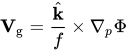
Great question! Above is our equation for the geostrophic wind, or the wind that is balanced with respect to Pressure Gradient Force (caused from a difference in atmospheric pressure at two locations) and the Coriolis Force (the force enacted on an object as a result of our Earth spinning on it's axis), While each hurricane can have it's own major impacts, may it be flooding, wind damage, long-term power outages, or coastal erosion, the Saffir-Simpson Hurricane Wind Scale is a fantastic way to determine the strength and potential hazards of a hurricane. Diving shallowly into our dynamical equations for the atmosphere, the horizontal wind is related to the horizontal pressure gradient, or the change in atmospheric pressure over a given distance. A hurricane is essentially a localized, very strong low pressure system, with extremely low pressure at the surface. The lowest pressure recorded in a hurricane was the Labor Day Hurricane of 1935 that struck the Florida Keys with 892 millibars of central pressure. Generally pressure at the surface ranges from 980 millibars to 1040 millibars in North Carolina depending on the season and the location in a weather pattern. A bar is the metric unit of pressure and is equivalent to the weight of the atmosphere above a location at sea level, hence the surface pressure being ~1000 millibars. In essence, the stronger the pressure gradient force, the faster the geostrophic winds will be, and the more opportunity the storm has to have more devastating impacts.


History of 'F'-Named Hurricanes in North Carolina

While in recent memory, Hurricanes beginning with the letter 'F' have had an incredible impact on North Carolina (Hurricane Fran in 1996, Hurricane Floyd in 1999, Hurricane Florence in 2000, Hurricane Fabian in 2003, and Hurricane Frances in 2004), the only one of that list to actually be a major hurricane upon landfall was Hurricane Fran. If you have lived in North Carolina for a while and remember these storms, you may recall that Fran was the only storm of that list in which major destruction was caused by wind. Floyd and Frances both caused catastrophic flooding from record-shattering rainfall totals, and Florence and Fabian both affected the coast with rip currents and beach erosion (Fun Story: Hurricane Fran is how I gained my interest in meteorology. The dream and fascination with the weather began back in 1996). With the exception of Fran, all the major hurricanes to make landfall in North Carolina had names that did not begin with 'F' (Emily 1993, Diana '84, Donna '60, Helene '58, Ione '55, Connie '55, Hazel '54, Great Atlantic Hurricane '44...). The complete list can be found here if you're interested.

Florence Again?

You may have noticed from the above paragraph that a hurricane named 'Florence' made landfall in 2000. Why is there another Hurricane named 'Florence'? The World Meteorological Organization implemented a list in 1953 of six years worth of names starting with 'A' to 'W' and with the exception of 'Q', 'U', 'X', 'Y', and 'Z' because names beginning with those letters are generally difficult to pronounce. The WMO implemented these lists because prior storms were referred to based on their coordinates in longitude and latitude, making it difficult to differentiate storms both during the event and in historical archives. The National Hurricane Center also mentions that a name can be removed from the lists in the event that the "storm is so deadly or costly that the future use of its name on a different storm would be inappropriate for reasons of sensitivity." Sandy, Katrina, Irma, Andrew, Hugo, Fran, Floyd, Hazel, and others have been removed from this list.

Florence: When, Where, How Strong

Hurricane Florence is one of three named tropical Cyclones in the Atlantic basin: Florence, Isaac, and Helene (Gordon formed in the Gulf and made it's way up through the belly of the United States as a Tropical Storm last week). As of 11:00 p.m. AST (Atlantic Standard Time, analogous to Eastern Daylight Time), Hurricane Florence was located at 24.6°N 57.7°W moving west at 7 mph with a minimum pressure of 974 mb and max sustained winds of 90 mph. Over the course of the next 4-5 days, it will move over warmer waters and into an area of lower wind shear, both conditions favorable for strengthening. Florence is expected to increase in strength to a major hurricane prior to making landfall. 

Levi Cowan, meteorologist and owner of "Tropical Tidbits" posted this latest GFS Ensemble track for Florence. As is apparent, most of the ensemble members show a trend for Florence to become a major hurricane and make landfall somewhere in North Carolina. While it is still too soon to determine exactly where landfall will occur, it is safe to say that the coasts of North Carolina, Virginia, and likely South Carolina will be affected by strong winds, heavy rains, and storm surge.

At this point, North Carolina Governor Roy Cooper has wisely declared a state of emergency in order to allow for numerous days of preparation ahead of a potentially devastating storm. The National Hurricane Center believes that the most likely path for Florence to take will be into the southern beaches of NC, which could mean direct landfall in Wilmington, however it is still too soon to pinpoint an exact beach as to where the biggest impacts will occur. At this point the best thing to do is prepare for the worst. Once Florence makes landfall, interaction with the land will cause the storm to weaken substantially, however even with weak winds this storm will still have an impact

Expected Hazards

1. Wind: As Florence will likely be a Category 3 or stronger storm at landfall, winds in excess of 110 mph can be expected within a couple dozen miles of the storm center. These winds could easily cause downed trees, power outages, damage to roofs and other structures, and damage from flying debris. The best thing to do would be stay away from windows (or even board up windows at the coast) and remain in interior rooms of the home throughout the initial stages of the event. 

2. Rain/Flooding: This storm is moving relatively slowly right now, but will pick up speed as it rounds the south end of the High pressure system establishing itself over the New England States. However, once the storm makes landfall, it will slow down substantially and the moisture nearby will be converted to rain within the storm. Some early precipitation forecasts show over 12" of rain to fall through the event in some areas (but still too early to tell exactly how much and where). Flooding could also lead to pollution of water used by the city, so be sure you have bottled water stocked up. 

3. Power Outages: Hurricane Florence might not produce as widespread or long-lasting power outages that Fran did back in 1996, however I suspect that due to the nature of this storm there will be extensive, widespread power outages along the coast and inland along the path Florence inevitably takes. Be sure you have your batteries and external batteries charged, flashlights at the ready, and candles where you can easily access them. 

4. Beach Impacts: Ahead of Florence, due to the expected wind direction and increased wave action along the beach, it would be wise to stay out of the water due to possible rip currents. In addition, through Florence's trip, I would expect some beach erosion along the the Carolinas and Virginia. 


*I will have a subsequent post early this week as Florence continues it's west-westnorthwest path toward the east coast.*

Friday, September 8, 2017

Subsequent Hurricane Irma Update

Major Hurricane Irma has just been upgraded back to a Category 5 storm with maximum sustained winds of 160 mph. It has been throwing forecasters for a loop as we try to figure out what it is going to do and where it is going to go. Well, now that we are closer to the event, models are able to represent the storm more closely to what will actually happen, and they are doing so with much more confidence and consistency allowing forecasters to zone in on the target zone.

Track Shift

Irma was always going to hook to the north; that was a fairly confident forecast for meteorologists. The issue arose with when and how sharp of a turn. At this point, the hope for Florida is that Irma has direct interaction with Cuba, that meaning the eye of Irma drifts over land so that friction with the surface as well as a change in wind shear can weaken this monster storm. If Irma does make landfall on Cuba, then Florida might see a category 3 or 4 version of the storm. However, if Irma continues on its westnorthwestward path, missing Cuba altogether (although effects from winds and rain will still affect Cuba and are affecting Cuba now), then with the fuel from the extremely warm (almost 90F!) waters south of Florida.

Where is Irma going?

As the cone suggests, our best forecast is that Irma will ride straight up the Florida peninsula, making its own stop at Disney World while the parks are closed down for 2 d
ays, and continue up through Atlanta, GA and into Tennessee. This is the best forecast we have for now with Hurricane Irma.

How Strong will it be?

Irma will be making landfall in south Florida as a Major Hurricane, meaning Category 3 or stronger. The main threat is if Irma does not make landfall over Cuba and continues to strengthen as a Category 5 prior to impact with the Florida Keys.

If Category 5

If Irma makes landfall as a Category 5 Hurricane, then it will remain a major hurricane likely until crossing into Georgia before being downgraded to a Category 2. South and Central GA will experience hurricane force winds (winds >74 mph) and South Carolina and North Carolina will experience tropical storm force winds (winds >35 mph). Then, Irma will be weakened to the point of a depression prior to entering Tennessee. Keep in mind... these are maximum sustained winds discussed here.

Gusts are a different story: Gusts in Florida could still reach 200+ mph... it would be devastating to all structures and vehicles in its way. Georgia could experience gusts exceeding 130 mph, SC gusts > 75 mph, and eastern and central NC gusts higher than 50 mph (while western NC like Asheville could see gusts exceed 70 mph). Tennessee will still likely see a breezy rain storm with gusts possibly exceeding 40 mph.

If Category 3/4

If Irma makes landfall as a Category 3, however, after interacting with the land and terrain of Cuba, then it could weaken enough to be categorized as a tropical storm prior to the central pressure exiting Florida. If this happened, then Georgia, the Carolinas, and Tennessee would receive little more than a windy rain storm.

***Currently (11:00 EST Friday, 09/08/2017) Irma is making a westward shift into Cuba, potentially bringing to fruition the Category 3 and preferred case for the United States***

What will happen along the coast?

East Coast

The east coast of Florida, GA, SC, and south NC will still receive wind, rain, and some storm surge from the power of the winds, however flooding will not be nearly as bad from the ocean itself. There is still a possibility of flooding from rain flowing downstream post-event, but surge will not swallow the coastline like what happened in Sandy or Harvey.

West Coast

The west coast of Florida, however, will receive more significant surge. While the strongest quarter of the storm, typically the Northeast quadrant of the storm, will not be shoving the Atlantic inland trying to gain real estate east of I-95, the southwest quadrant of Irma will still have an effect on the west coast as Irma moves further north. Cape Coral, Sarasota, and Tampa will likely all receive more significant storm surge now that the westward shift is being realized.

To the right I have posted an image from the RadarScope (copyright) application with the Miami, Florida radar image. At 9:58 CDT the outer rain bands were quite visible on the Miami radar.

Stay tuned to your local meteorologists for the most up-to-date information. The same key messages apply, and it is recommended that coastal Floridians evacuate, and take your pets with you. DO NOT LEAVE YOUR PETS BEHIND. It is very sad to hear about pets, let alone human beings, being left behind in storms such as these. They are helpless, and after some of the things I saw in the Harvey aftermath, people can be cruel beings. Please take ALL of your FAMILY MEMBERS with you. They love you unconditionally, and we can all learn a thing or two from that kind of love the Lord commands. Be safe all, and God bless.

Thursday, September 7, 2017

Katia, Jose, and Irma... Oh My!!!

'Tis the Season

The tropics are alive and well as we have reached the peak of hurricane season, and it's not going to stop soon. Currently there are three named storms in the Atlantic basin: Hurricane Irma, Hurricane Jose, and Hurricane Katia. Hurricane Katia will spin up some moisture and head down into central Mexico providing some much-needed rain down there. I will discuss Irma and Jose further below.

Major Hurricane Irma

Hurricane Irma has been catching the nation's attention for almost a week now. Riding the wake of Hurricane Harvey, which just spent a week parked over southeast Texas dumping 7-day record-breaking rainfall totals of over 60" and producing catastrophic flooding, Irma has been forced on a more westward path, alerting the Caribbean and United States of the raw power of God's creation. Tuesday afternoon (18Z 20170906), Air Force Reconnaissance recorded wind data on their flight, including max sustained winds exceeding 185 mph.

The Caribbean Islands are experiencing Category 5 hurricane Irma now and the next island to receive a direct hit will be will be Haiti and the Dominican Republic. Some islands, including Barbuda and St. Martin, have basically been destroyed... In Barbuda, all cell phone towers have been knocked over, the reinforced steel bent and twisted from the strength of the winds.

One aspect of this storm to keep in mind is its relation to the Synoptic, or large-scale environment. High pressure building into the Great Plains is forcing Irma on a more westnorthwestward path, however as the trough ahead of it lifts out into the northern Atlantic, Irma is expected to make a sharp turn to the northnortheast. It has already begun heading more NW than earlier, and models now have major hurricane Irma running up the east coast, potentially making landfall in Miami on Sunday morning/afternoon.


Georgia and the Carolinas are currently in the line of sight for Irma, however northern Hispanola, the Bahamas, and Florida reside in the immediate path. Much destruction has already occurred in the Caribbean, and although Irma has weakened slightly, more is to be expected with the now max sustained 180 mph winds. I have pictured to the left the most updated ensemble projections for the path of Hurricane Irma of the ECMWF (European Model, top) and the GFS Ensemble (American long-range Model, bottom). Irma is expected to cut back, but even now the models are not sure where exactly it will go. Whatever the case may be, the Bahamas and South Florida need to be preparing for the worst. Below I have also shared NOAA's main points regarding the devastation capable of Irma. 


Here's what to prepare for (Irma edition):


High winds: While flooding remains a threat, the strong wind capable of toppling buildings and tossing automobiles like matchbox cars is the real threat initially. Keep in mind, 180 mph is about how fast planes fly when landing or taking off. It is about three times that of highway speed, and this powerful wind is capable of moving/uprooting/toppling just about anything. Even if this storm weakens as it moves up the coast and veers toward the Carolinas, as some model runs would suggest, places like Asheville, NC could experience hurricane-force wind gusts exceeding 75 mph.

Flying debris: Piggybacking off of the high wind potential, debris will be carried by winds. These winds can be equated to those found in an EF-4 tornado, which tends to flatten anything in it's path. The straight-line winds in a hurricane do not have quite the devastating effect of those found in an EF-4 solely because the pressure differential is much greater in a tornado, because it is a smaller cyclone of rotation, but nevertheless the winds can flatten structures and fling debris through the air with ease.

Power outages: Cause and effect from the first two potential hazards leads us to the third hazard to prepare for, and that is widespread power-outages. While Irma will likely move quickly up the coast, the sheer strength of the storm will blow over power lines and possibly even ruin substations and power stations depending on their location... In this case, millions of people could lose power for an extended period of time while power companies work extra overtime in order to get everyone back on the grid. Make sure you have supplies prepared in the event of extended power outages.

Flooding: The final hazard I want to rehash is the possible of catastrophic flooding. This storm will not park itself over one location for a week as did Harvey, but the strength of the wind will cause massive storm surge along the coast, especially between Charleston and Wilmington should the current path come to fruition, and heavy rainfall further inland will flow down the narrow river basins overrunning banks potentially flooding downstream neighborhoods as we saw with Hurricane Matthew last year.

Hurricane Jose

Even just 24 hours ago, Jose was "supposed" to be a fish storm and curve back out to sea. Mother nature had a different idea in mind. The prevailing easterlies are proving to be an effective mode of transportation for Hurricane Jose, and now it is expected to take a more northwestward path. The danger now lies with the northern Caribbean islands which just got decimated by Hurricane Irma... and that danger is that another Hurricane will be making its visit in likely before the end of the weekend. There are reports that 90% of structures and automobiles have been destroyed on the Island of Barbuda, and now there is a possibility of another Hurricane, possibly Major Hurricane, wreaking additional havoc less than a week later. Hurricane shelters and other shelters alike were demolished from the record-breaking winds of Irma, and now another storm poses a threat to the Caribbean.

Essentials

Below is a list of items which would be necessary for survival should the above situations occur, those including flooding, widespread power outages, and wind damage.

1. Bottled Water
2. Canned Foods
3. Flashlight with extra batteries
4. External Phone Charger/Battery Pack
5. Some means of receiving updated information in the event of a power outage (i.e. phone, battery-powered weather radio, etc.)
6. Tent, sleeping bags, and other essentials for sleeping outdoors should residential structures become damaged to a point of endangering those residing in them.
7. Safe location away from the coast/coastal waterways

Not all of these may be possible, but now that NC and SC are both in a state of emergency, I highly recommend taking the necessary steps to prepare yourself and your loved ones for the worst, obviously praying and hoping for the best. The death toll has begun in Barbuda with already 6 people being proclaimed dead, and that number will only rise as conditions clear behind the storm ahead of Jose and damage can be assessed. Please do not take this storm for granted, as it is a life-threatening storm capable of catastrophic damage.


Wednesday, April 5, 2017

Evening Storms and Overnight Severe in NC

We have an interesting situation setting up with good potential for a severe outbreak in the Southeast, including North Carolina. A trough with a strong jet streak upstream is becoming negatively tilted. In layman's terms, that means that it is increasing in strength rapidly and gaining atmospheric potential to unwind in a severe way.

Here's the situation: Storms will be forming and rolling through around dinner time. These storms, for central North Carolina, will more likely be our normal thunderstorms than not. The main event will come in the wee hours of Thursday morning and last into the morning commute (3:00 a.m. until 7:00 a.m.), making anything severe that much more dangerous due to the lack of available light for observation. Soundings indicate the possibility for a Linear Convective System to establish itself prior to moving eastnortheastward across the state, with growing potential for isolated supercell formation and tornadoes.

|A Supercell Thunderstorm is one in which the main core involves a lower, rotating mass of clouds called a mesolow. This rotation allows for super strong updrafts capable of creating and maintaining hail stones larger than golf balls and in some cases larger than tennis balls, and if the conditions are right and the rotation persists, a tornado can form. There are many more factors involved in tornado formation which I will not go into at this point.|

Threats:

The imposing danger is split into 3 different parts.

1. Strong Winds: This not including tornadoes... Atmospheric sounding profiles would suggest that throughout the event, 850 and 700 mb wind speeds would produce non-insignificant damage if mixed down to the surface, and currently it looks as though with high equivalent potential temperature (theta-e) air will be mixed into the system by the Gulf with southerly winds ahead of the line. This high theta-e air mixed into the middle of the atmospheric profile will provide instability (even though the surface instability from surface heating will not due to the time of day), and mixing to the surface could occur, producing surface instability and atmospheric mixing. These winds, when mixed down, could blow at a rate of 50 or 60 mph, a speed capable of toppling trees and power lines.

2. Hail: The hail danger is fairly straight forward. If hail forms, it will likely cause damage. If it's large enough, it could cause window breakage and crop damage in addition to dents in the roofs and hoods of cars.

3. Tornadoes: Tornadoes can form in two of the aforemention situations... either in the isolated supercell thunderstorms, or in a piece of a multicell line that accelerates due to strong winds from aloft. One piece I did not mention about those strong winds in point 1, is that if they mix down they can aid the advancement of a piece of the line of t-storms ahead of the rest of the line. In this case, the northern portion of that advancing segment could wrap around and allow for tornadic formation. The other situation is within a supercell thunderstorm, where the rotation found in the mesocyclone (aforementioned "mesolow") extends down to the surface.

Keep all forms of social media and warning prepared for tonight, as these storms will be arriving while most everyone is asleep, increasing the danger which exists with already dangerous storms. I will be retweeting from @miscan5000 and sharing by miscan5000 on Facebook overnight to help keep updates coming. Have an awesome day everyone! Keep your eyes to the sky!

Friday, January 6, 2017

Subsequent "Winter is Coming" Accumulation Update for North Carolina

Updated information is necessary!

The band of expected highest accumulation has shifted to the northeast from earlier. Temperatures are a bit warmer aloft than expected a few days ago for this storm. The transition zone is setting up around the Triangle as it usually does with these types of systems. However, 

New Accumulation Expectations

Many respected meteorologists in the area have been seeing similar hints from the models. 

Mountains: 

Boone, Asheville, and other areas in the foothills and higher elevations can expect from 3-7"

Western Piedmont: 

Salisbury, Asheboro, Winston Salem, Greensboro, and up to Danville, VA can expect highest accumulations. Most of these areas can expect 6-10", and higher accumulations will be experienced depending on where heavier mesoscale snow bands set up. Some areas, if conditions are favorable throughout the night into the morning, could see over 12"

Eastern Piedmont: 

Durham, Chapel Hill, Hillsborough, up into Roxboro, Henderson, and down into Pittsboro and Siler City could also see greater accumulation of 6-10" with the same case concerning snow banding. 

Raleigh, Wake Forest, Louisburg, Rocky Mount, and up to Roanoke Rapids are expecting now lower totals of snowfall as there is still that warm air aloft. If dendrites form higher up in the atmosphere, then melt in that warm layer, it will not take much time to cool the atmosphere to freezing at this layer. When this happens we will make the transition to snow here. Snow totals though are backing off to 2-4" for now. We still need to see what happens with that warm layer before making another update on accumulation amounts. 

Sandhills / Upper Coastal Plains: 

Laurinburg, Fayetteville, and Goldsboro have the best chance of snow accumulation in the Sandhills which will start later than other areas once the temperature cools off. All snow is expected by daybreak, however most of the moisture will have precipitated by that point. I am forecasting up to 1-2" max in these areas.

Greenville, Oak City, Murfreesboro, and over to Elizabeth City will be on the transition zone or southeast of it. Most of the accumulation in these towns and cities will be that of sleet transitioning to rain/freezing rain. Snow that falls in these areas will begin closer to lunch and accumulations of less than 1" are expected.

Lower Coastal Plains: Most everywhere else in the quadrant east of I-95 and south of US-64 can expect mostly rain transitioning to a wintry mix late in the morning tomorrow. Very little if any snow accumulation is expected.